
 inquiry@tibettourism.com








Tibet Location Maps
Most tourists may only know there is a magical place in China, they have no idea where Tibet locates in the map. They want to figure out the location when they are planning their Tibet tour. So, the following content will show you where Tibet is on the map of China, Asia, and the world. You can also find more details on the location maps of Tibet city, prefecture and attractions.
Location Maps of Tibet Autonomous Region
Tibet, the second largest Chinese administrative division behind Xinjiang, enjoys a total area of 1.22 million square kilometers. It is well known as "the roof of the world" due to its average altitude of 4,000 meters above sea level. Because of its unique geographic location, Tibet has so much to offer to tourists with its breathtaking and mysterious scenery. Having a Tibet tour has been the ultimate goal of most adventurous tourists.
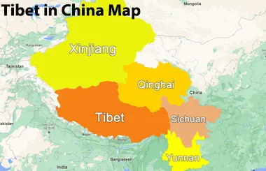
Tibet in China Map
Tibet borders four provincial-level regions of the Chinese Mainland: Xinjiang to the north, Qinghai to the northeast, Sichuan to the east, and Yunnan to the southeast. These neighboring regions are also the most popular tourist destinations in China, attracting visitors from around the world.
Sichuan, especially Chengdu, is the best gateway to Tibet. The Chengdu to Lhasa Train Z322 takes tourists to enter Tibet every other day with only 34 hours and 38 minutes. And there is also Sichuan-Tibet Highway G318 leading tourists to have an overland trip to Lhasa. Flights from Chengdu to Lhasa are available daily. Tourists can also find a great overland route G214 from Yunnan to Tibet. Speaking of Qinghai, Xining is the starting point of Qinghai-Tibet Railway as well as Qinghai-Tibet Highway G109. Xinjiang provides one flight to Lhasa with a stopover in Xining. Besides, there is also an overland route G219 connecting Xinjiang and Tibet, covering more than 2,700km.
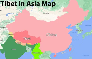
Tibet in Asia Map
Located in the southwest of China, Tibet borders Myanmar, Bhutan, Nepal, and India. The border line lasts more than 4,000 kilometers, which makes it the important gateway to China's southwest border area.
From the map of Asia, Tibet sits in the heart of this continent. It boasts an area larger than most countries in Asia. That's why this land can foster many unique culture and picturesque scenery that attract so many tourists to visit.
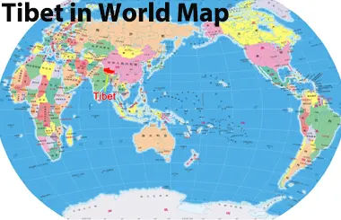
Tibet in World Map
Tibet locates between 26 degrees and 37 degrees north latitude and 78 degrees and 99 degrees east longitude. Even if seeing from the map of the world, it can be spotted easily with its large area. It has the highest mountain in this world - Mount Everest at 8,848m, as well as other 10 peaks over 8,000m. So, if you are planning to visit China, don't miss the chance to have a Tibet tour.
Location Maps of Tibet City, Prefecture and Attraction
Lhasa Location Maps
Lhasa, the capital of the Tibet Autonomous Region, lies on the Tibetan Plateau in southwestern China. The maps below show its location in Tibet, China, Asia, and the world.
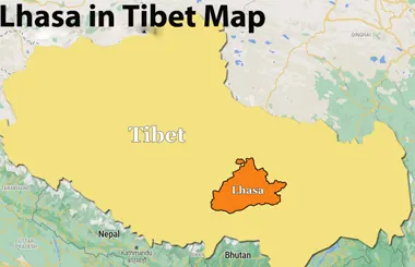
Lhasa in Tibet Map
Lhasa lies in south-central Tibet, along the Lhasa River, a tributary of the Yarlung Tsangpo River. At an elevation of about 3,650 meters (11,975 feet), the city is home to major landmarks such as the Potala Palace, Jokhang Temple, and Barkhor Street. Its location also makes it a convenient starting point for exploring other parts of Tibet.
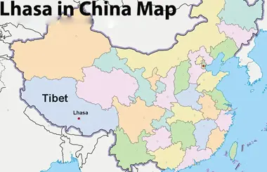
Lhasa in China Map
On a map of China, Lhasa lies west of Chengdu and southwest of Xining. Flights and trains connect Lhasa with several major Chinese cities, including Beijing, Shanghai, Chengdu, and Xining, depending on the available schedules.
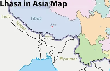
Lhasa in Asia Map
On a map of Asia, Lhasa is located on the Tibetan Plateau in southwestern China, north of Nepal and India. Its position makes it a useful reference point for understanding the geography of the Himalayan region.
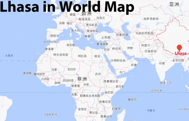
Lhasa in World Map
Lhasa lies at approximately 29.65° N latitude and 91.13° E longitude. Its high elevation and location on the Tibetan Plateau make it one of the world's highest major cities.
- Lhasa Maps: Location Map, City Map, Administrative Map, Tourist Map, Transportation Map
- Lhasa Location Map: Where Is Lhasa Located on a Map?
- Lhasa Chengguan District: Downtown Map & Top Attractions
- Lhasa City Map: Top Attractions, Districts & Travel Routes
Shigatse Location Maps
Shigatse is the second-largest city in Tibet, known for its rich Tibetan Buddhist heritage, historic monasteries, and proximity to Mount Everest. The maps below show its location in Tibet, China, Asia, and the world.
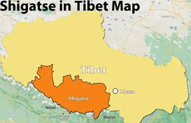
Shigatse in Tibet Map
Shigatse is located in southwestern Tibet and west of Lhasa. It lies at an elevation of about 3,830 meters (12,566 feet) above sea level. On a Tibet map, Shigatse is an important transport hub for trips to Everest Base Camp, Tingri, and western Tibet.
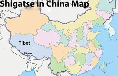
Shigatse in China Map
On a China map, Shigatse is located in the southwestern part of China, within the Tibet Autonomous Region. You can reach Lhasa from the Chinese Mainland and then continue to Shigatse by road, train or flight, making Shigatse a convenient stop on a Tibet itinerary. Its location also makes it an important gateway to Mount Everest and other destinations in the Himalayas.
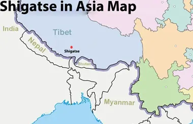
Shigatse in Asia Map
On a map of Asia, Shigatse is located in southwestern China, north of the central Himalayas. Its position in southern Tibet makes it an important reference point for travelers exploring the Himalayan region.
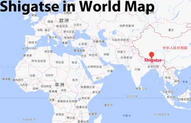
Shigatse in World Map
Shigatse lies at approximately 29.27° N latitude and 88.88° E longitude. It is known for its Tibetan Buddhist heritage and its role as a gateway to Mount Everest and other Himalayan destinations.
- Shigatse Maps: Essential Location, Tourist & Transport Guide
- Shigatse and Yamdrok Lake Maps (2026 Updated)
Mount Everest Location Map
The maps below show its location in Tibet, China, Asia, and the world, helping travelers understand where Everest Base Camp is located and how to reach it from Lhasa.
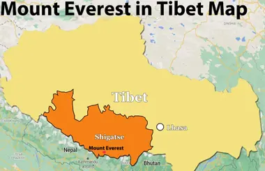
Mount Everest in Tibet Map
On a Tibet map, Mount Everest lies in Tingri County, within Shigatse City in southern Tibet. Everest Base Camp on the mountain’s northern side offers views of the world’s highest peak. Travelers can reach it by road from Lhasa via Shigatse and Tingri.
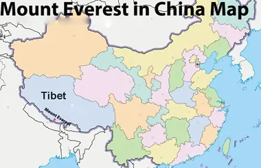
Mount Everest in China Map
On a map of China, Mount Everest lies on the border between China and Nepal, within the Himalayan range.
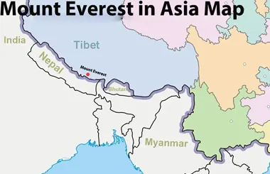
Mount Everest in Asia Map
Mount Everest is part of the Himalayan mountain range, which stretches across several countries in South Asia. Its location makes Mount Everest one of Asia’s most prominent natural landmarks and a major destination for mountaineers and adventure travelers.
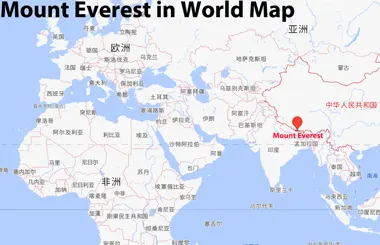
Mount Everest in World Map
On a world map, Mount Everest is located in Asia, within the Himalayan range between China and Nepal. At 8,848.86 meters (29,031.7 feet) above sea level, it is the highest mountain on Earth. Its precise location is approximately 27.99° N latitude and 86.93° E longitude. This remote mountain attracts climbers, trekkers, and travelers from around the world.
- Mount Everest Maps: Location Map, Trek Map, Climbing Map, Road Map to EBC
- Tibet Everest Base Camp Trek Map
- Rongbuk Glacier Travel Guide: Map, Facts & Itineraries
Ngari Location Maps
Ngari is known for its vast high-altitude landscapes, sacred Mount Kailash, and Lake Mansarovar. The following maps show Ngari’s location in Tibet, China, Asia, and the world, helping travelers plan their Ngari journey.
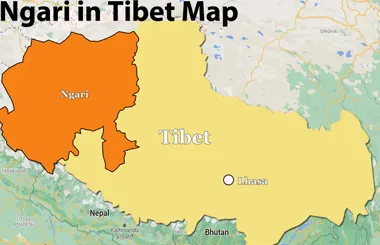
Ngari in Tibet Map
Ngari occupies the far western part of the Tibet Autonomous Region. It is home to Mount Kailash and Lake Mansarovar, two of the region’s most important sacred sites.
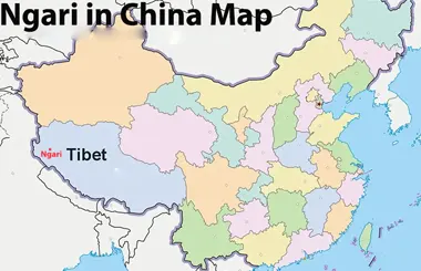
Ngari in China Map
On the map of China, Ngari defines the far western boundary of the Tibet Autonomous Region, sharing extensive borders with Xinjiang to the north and international frontiers to the west. It forms an indispensable ecological shield and a critical strategic border region in western China. Due to its remote location and high altitude, Ngari is far from major Chinese cities and usually requires a long overland journey or a flight to Ngari Gunsa Airport or Purang Airport.
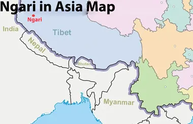
Ngari in Asia Map
Ngari lies in the western part of the Tibetan Plateau, near the Himalayas and the borders with India and Nepal. The wider region is associated with the headwaters of several major Asian rivers, including the Indus and Sutlej.
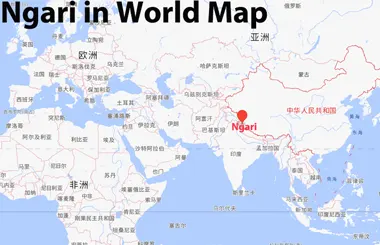
Ngari in World Map
On a world map, Ngari lies on the Tibetan Plateau, one of the world's highest and most extensive elevated regions. It is globally celebrated for its stark, otherworldly landscapes, deep spiritual heritage, and the historic ruins of the ancient Guge Kingdom.
Kailash Mansarovar Location Maps
Mount Kailash and Lake Mansarovar are located in the Ngari Prefecture of western Tibet. These sacred sites are important destinations for pilgrims. The following maps help you better plan a Kailash Mansarovar Yatra.
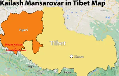
Kailash Mansarovar in Tibet Map
Mount Kailash and Lake Mansarovar are located in the Ngari Prefecture of western Tibet, near the borders of India and Nepal. Mount Kailash rises to 6,638 meters (21,778 feet) above sea level, while Lake Mansarovar lies to its southeast at an elevation of about 4,590 meters (15,060 feet). A Tibet map shows their locations near other regional landmarks, including Lake Rakshastal and the town of Darchen, the main starting point for the Mount Kailash kora.
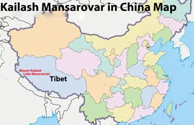
Kailash Mansarovar in China Map
On a China map, Mount Kailash and Lake Mansarovar are located in the western part of the Tibet Autonomous Region. They lie in Burang County, Ngari Prefecture, close to China's borders with India and Nepal. Their remote location makes them important destinations for travelers exploring western Tibet, and most visitors travel overland from Lhasa or enter Tibet through Nepal as part of an organized tour.
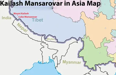
Kailash Mansarovar in Asia Map
On a map of Asia, Mount Kailash and Lake Mansarovar lie on the Tibetan Plateau in western Tibet. Mount Kailash is sacred to followers of Hinduism, Buddhism, Jainism, and the Bon tradition, while Lake Mansarovar is also revered as a holy lake, particularly in Hinduism. Together, they form one of the most important pilgrimage destinations in the region.
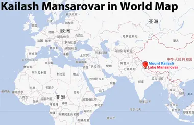
Kailash Mansarovar in World Map
On the world map, Mount Kailash and Lake Mansarovar are located on the Qinghai-Tibet Plateau at approximately 31.0° N latitude and 81.3° E longitude. Although both sites are remote and difficult to reach, they hold global religious significance and attract international pilgrims and travelers. Mount Kailash is widely regarded as a sacred spiritual center, often described as the “Axis Mundi,” while the surrounding Tibetan Plateau offers spectacular high-altitude scenery.
- Kailash Himalaya: Location, Map, Routes & Travel Guide
- Kailash Parvat Map: Where is Kailash Parvat in Map
- Kailash Parvat Location: Where is Kailash Parvat
- Kailash Range: Where Is Kailash in Himalaya
- Mansarovar Lake Map: Where is Mansarovar Lake in Map
- Kailash Mansarovar Map: Where is Kailash Mansarovar Map
Nyingchi Location Maps
Nyingchi is known for its forests, peach blossom, snow-capped mountains, and the Yarlung Tsangpo Grand Canyon. The maps below show its location in Tibet, China, Asia, and the world.
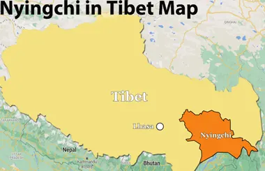
Nyingchi in Tibet Map
Nyingchi is located in southeastern Tibet, where the terrain is generally lower than in many other parts of the plateau. The region is known for its relatively mild climate and attractions such as Basum Tso, the Yarlung Tsangpo Grand Canyon, and Mount Namcha Barwa.
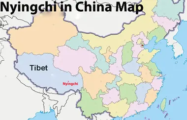
Nyingchi in China Map
On a map of China, Nyingchi lies in the southeastern part of the Tibet Autonomous Region, near the borders with Yunnan and Sichuan. National Highway G318 is one of the main road routes connecting the region with eastern Tibet and neighboring provinces.
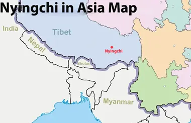
Nyingchi in Asia Map
On an Asia map, Nyingchi is located in southwestern China, on the eastern edge of the Himalayas. It lies near South Asia, with India to the south and Myanmar to the southeast. This strategic location, combined with its dramatic mountain scenery and deep river valleys, makes Nyingchi a distinctive destination for exploring the natural landscapes of the Himalayas.
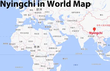
Nyingchi in World Map
Nyingchi lies at approximately 29.65° N latitude and 94.36° E longitude in southeastern Tibet, China. It is especially known for its annual Spring Peach Blossom Festival.
Shannan Location Maps
Shannan is known as one of the important birthplaces of Tibetan civilization. It features historic monasteries, ancient cultural sites, and the beautiful Yarlung Tsangpo River Valley. The following maps show Shannan’s location in Tibet, China, Asia, and the world.
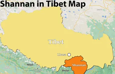
Shannan in Tibet Map
On the Tibet map, Shannan is located in the southern part of the plateau, directly south of Lhasa, east of Shigatse, and west of Nyingchi. A Shannan map helps you locate key attractions such as Yumbulagang Palace, Samye Monastery, and Yamdrok Lake. The region is an excellent destination for exploring Tibetan history, culture, and natural scenery.
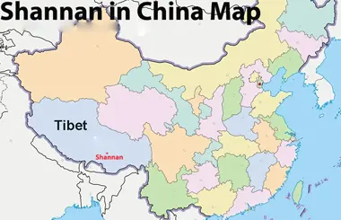
Shannan in China Map
On a map of China, Shannan lies in the southern part of the Tibet Autonomous Region, near the borders with India and Bhutan. Its historic sites make it a worthwhile stop for travelers exploring southern Tibet.
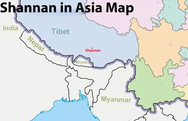
Shannan in Asia Map
On a map of Asia, Shannan lies in southern Tibet, north of Bhutan and the Himalayan region of India. Its location places it within the wider Himalayan geographical region.
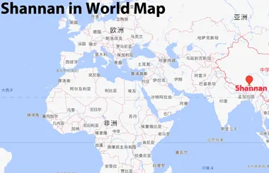
Shannan in World Map
On a world map, Shannan is located in Asia, in the southern part of the Tibet Autonomous Region, China. Its administrative center, Tsetang, lies at approximately 29.25° N latitude and 91.77° E longitude. Although Shannan is less familiar to many international travelers than Lhasa, it offers valuable insights into Tibetan history and culture, along with scenic views of the surrounding mountains.
Nagqu Location Maps
Nagqu is known for its vast grasslands, high-altitude lakes, and traditional Tibetan nomadic culture. The following maps show Nagqu’s location in Tibet, China, Asia, and the world.
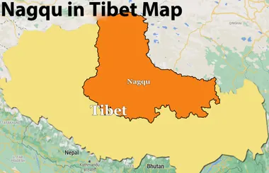
Nagqu in Tibet Map
Nagqu is located in northern Tibet. It borders Lhasa to the south and lies near the Tanggula Mountains to the north. A Nagqu map helps you locate major attractions such as Namtso Lake, the Changtang grasslands, and the Tanggula Mountain region. Its high altitude and wide-open landscapes make Nagqu a distinctive destination for exploring northern Tibet.
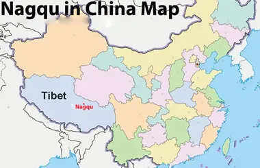
Nagqu in China Map
On a map of China, Nagqu lies in northern Tibet, on the Qinghai–Tibet Plateau. The Qinghai–Tibet Railway and major highways connect this part of the plateau with other regions, although available transport options depend on the destination and schedule.
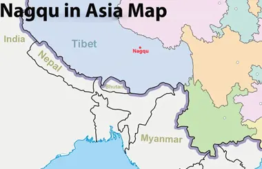
Nagqu in Asia Map
On a map of Asia, Nagqu lies in the northern Tibetan Plateau, within the Changtang region. Its landscape includes vast grasslands and high-altitude lakes such as Namtso and Serling Tso.
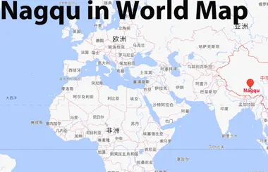
Nagqu in World Map
Nagqu lies at approximately 31.48° N latitude and 92.05° E longitude in northern Tibet, China. The region is part of the Changtang area, known for its grasslands, alpine ecosystems, and wildlife.
Chamdo Location Maps
Chamdo (Qamdo) is serving as the eastern gateway to Tibet and the historic hub of the Kham cultural sphere. The following maps show Chamdo’s location in Tibet, China, Asia, and the world.
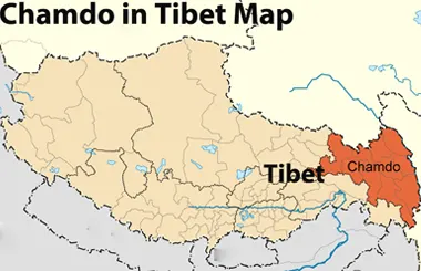
Chamdo in Tibet Map
Chamdo lies in the northeastern part of the Tibet Autonomous Region, near the upper reaches of the Lancang (Mekong) and Jinsha rivers. A Chamdo map helps locate places such as Karub District, Riwoche, and Zogang, as well as routes connecting eastern Tibet with Lhasa and neighboring regions.
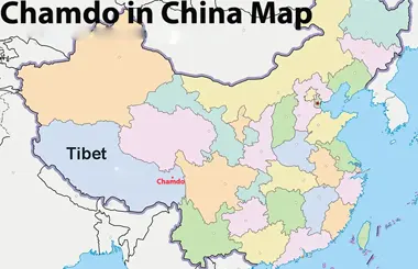
Chamdo in China Map
On a map of China, Chamdo lies in eastern Tibet and connects with Sichuan and Yunnan via major highways, including the Sichuan–Tibet and Yunnan–Tibet routes.
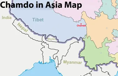
Chamdo in Asia Map
On a map of Asia, Chamdo lies in the Hengduan Mountains of eastern Tibet. The region is characterized by deep river valleys and mountainous terrain, with major rivers including the Lancang (Mekong) and Jinsha (Yangtze) flowing through or near the wider area.
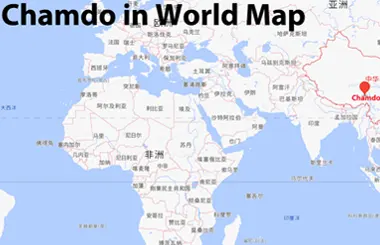
Chamdo in World Map
On the world map, Chamdo is located at approximately 31.1° N latitude and 97.1° E longitude on the Qinghai-Tibet Plateau. It is globally distinguished by its dramatic alpine canyon terrain, deep river valleys, and rich cultural heritage along ancient trans-Asian trade routes.
No documents found.
Most Classic Tibet Tour Packages
Our Tibet small group tours offer a range of itineraries from 4 to 16 days. Explore Lhasa’s cultural highlights, visit Everest Base Camp, discover the sacred Mount Kailash and Lake Mansarovar, or travel overland between Lhasa and Kathmandu. Whether you prefer a short cultural trip or an extended pilgrimage and adventure, you can choose the itinerary that best suits your interests and schedule.
-
![Holy Lhasa City Small Group Tour]() Small Group Tour
4 Days Holy Lhasa City Small Group Tour
Promo: Explore the Architecture & Landscape of Lhasa
Dates & Price
![rili]()
![xiala]()
-
![Lhasa Shigatse Mount Everest Small Group Tour]() Small Group Tour
8 Days Lhasa Shigatse Mount Everest Small Group Tour
Promo: Once-in-a-lifetime chance to face the tallest mountain in the world
Dates & Price
![rili]()
![xiala]()
-
![Lhasa to Everest Kailash and Mansarovar Small Group Tour]() Small Group Tour
15 Days Tibet Mount Kailash and Lake Mansarovar Small Group Tour
Promo: Western Tibet tour around Mount Kailash
Dates & Price
![rili]()
![xiala]()
-
![Lhasa Yamdrok Shigatse Central Tibet Culture Small Group Tour]() Small Group Tour
6 Days Lhasa Yamdrok Shigatse Central Tibet Culture Small Group Tour
Promo: Taste the essence of Tibetan Culture in central Tibet
Dates & Price
![rili]()
![xiala]()
-
![Lhasa Shigatse Everest Base Camp Namtso Small Group Tour]() Small Group Tour
9 Days Lhasa Shigatse Everest Base Camp Namtso Small Group Tour
Promo: Unveil the profound spirituality and natural beauty that lie within the heart of Tibet.
Dates & Price
![rili]()
![xiala]()
-
![Lhasa Everest Kailash Mansarovar Guge Kingdom Full Moon Small Group Tour]() Small Group Tour
17 Days Lhasa Everest Kailash Mansarovar Guge Kingdom Full Moon Small Group Tour
Promo: Explore western Tibetan spirituality and culture around the sacred Mount Kailash
Dates & Price
![rili]()
![xiala]()
-
![Lhasa Yamdrok Lake Small Group Tour]() Small Group Tour
5 Days Lhasa Yamdrok Lake Small Group Tour
Promo: Marvel at the Heavenly Lake - Yamdrok Lake
Dates & Price
![rili]()
![xiala]()
-
![Lhasa Namtso Lake Small Group Tour]() Small Group Tour
5 Days Lhasa Namtso Lake Small Group Tour
Promo: Expose the age-old spiritual wisdom and magnificent natural wonders that are concealed in the heartland of Tibet.
Dates & Price
![rili]()
![xiala]()
-
![Lhasa Ganden Monastery Drak Yerpa Small Group Tour]() Small Group Tour
5 Days Lhasa Ganden Monastery Drak Yerpa Small Group Tour
Promo: Reveal the deep-seated religious essence and stunning landscapes that exist within the core of Tibet
Dates & Price
![rili]()
![xiala]()
-
![Old Tingri to Everest Base Camp Trek Small Group Tour]() Small Group Tour
10 Days Old Tingri to Everest Base Camp Trek Small Group Tour
Promo: Embark on the ultimate trekking adventure to Mount Everest Base Camp.
Dates & Price
![rili]()
![xiala]()
-
![Tibet Nepal Bhutan Small Group Tour]() Small Group Tour
13 Days Tibet Nepal Bhutan Small Group Tour
Promo: Unveil the spiritual and natural mysteries concealed in the Himalayan Mountains.
Dates & Price
![rili]()
![xiala]()
-
![Kathmandu to Lhasa Overland Small Group Tour with EBC]() Small Group Tour
8 Days Kathmandu to Lhasa Overland Small Group Tour with EBC
Promo: Drive Across Himalaya Overland Tour with altitude rising slowly
Dates & Price
![rili]()
![xiala]()
-
![Lhasa Everest Base Camp Kathmandu Overland Small Group Tour]() Small Group Tour
7 Days Lhasa Everest Base Camp Kathmandu Overland Small Group Tour
Promo: Classic overland travel route from Lhasa to Kathmandu via Nyalam
Dates & Price
![rili]()
![xiala]()
-
![Lhasa Everest Kailash Mansarovar Zhangmu Kathmandu Small Group Tour]() Small Group Tour
12 Days Lhasa Everest Kailash Mansarovar Zhangmu Kathmandu Small Group Tour
Promo: Uncover the spiritual and natural secrets hidden within Tibet
Dates & Price
![rili]()
![xiala]()
-
![Lhasa Everest Kailash Mansarovar Lhasa Tour with Inner Travel Gateway]() Small Group Tour
16 Days Lhasa Everest Kailash Mansarovar Lhasa Tour with Inner Travel Gateway
Promo: Complete 3-Day Kailash Kora and 1-Day Inner Kora Gateway Excursion
Dates & Price
![rili]()
![xiala]()








FAQs on Tibet Location Maps
The major cities and regions in Tibet include Lhasa, Shigatse, Nyingchi, Chamdo, Nagqu, Shannan, and Ngari. Lhasa is the regional capital, Shigatse is a key gateway to Everest Base Camp, Nyingchi is known for its forests and mountain scenery, and Ngari is famous for Mount Kailash, Lake Mansarovar, and its vast, remote landscapes.
2) Which countries share borders with China Tibet Autonomous Region?China Tibet Autonomous Region borders India, Nepal, Bhutan, and Myanmar. It also borders other parts of China, including Xinjiang, Qinghai, Sichuan, and Yunnan. A location map helps you understand Tibet's position within China and its relationship to neighboring countries.
3) Where are the main airports and railway stations in Tibet?Lhasa Gonggar International Airport is the main air gateway to Tibet, while other airports include Nyingchi Mainling, Shigatse Peace, Shigatse Tingri, Ngari Purang, and Ngari Gunsa airports. Lhasa Railway Station is the main railway hub for travelers arriving by train from cities such as Xining, Beijing, and Chengdu. Other important stations include Shigatse Railway Station and Nyingchi Railway Station. Check your route on a map before traveling, as transport connections vary by destination.
4) How far is Lhasa from Mount Everest and Mount Kailash?Lhasa is about 600 km from Mount Everest Base Camp and approximately 1,200 km from Mount Kailash by road, depending on the route. Driving to Everest Base Camp usually takes around 1–2 days, while reaching Mount Kailash typically takes several days. Both journeys cross high-altitude areas, so allow enough time for acclimatization and sightseeing.
5) How can I use a Tibet location map to plan my trip?Start by locating your main destinations on the map and checking which administrative divisions they belong to. Then compare their relative locations to create a logical itinerary. Before booking transport, check actual road distances, travel times, and access restrictions, as a location map does not provide all the details needed for route planning.
6) Which map app is best for planning a trip to Tibet?A detailed Tibet tourist map is useful for locating major attractions, cities, and travel routes. Google Maps may have limited information in some areas, so travelers can also use Apple Maps or Amap for navigation. For remote destinations, confirm road conditions and routes with your local travel agency.
7) Can I use offline maps in Tibet?Yes. You can download offline maps before traveling to Tibet and use them to check locations and routes without an internet connection. Google Maps offers offline maps in supported areas, but some information and navigation features may be limited in China. Download the required map areas in advance and save important locations, such as hotels, railway stations, and attractions. For remote areas, confirm your route with your local guide.
8) How can I travel between major destinations in Tibet?Most travelers explore Tibet by road, either in a private vehicle or as part of an organized tour. Popular routes connect Lhasa with Shigatse, Nyingchi, and Everest Base Camp. Trains and flights are also available on selected routes, depending on the destination and schedule.
