
 inquiry@tibettourism.com


.webp)


Lhasa Location Map: Where Is Lhasa Located on a Map?


.webp) Content
ContentWhere is Lhasa located? How do you get there? What attractions are nearby? First-time visitors to Lhasa often have questions like these. We have prepared comprehensive Lhasa maps - including a Lhasa location map, a Lhasa district map, maps of Lhasa surrounding areas and provinces, as well as a Lhasa train map, a Lhasa flight map, and a Lhasa road map, etc, to help you quickly grasp the city's layout, the distribution of key attractions, and regional transport routes, enabling you to plan your Lhasa tour more efficiently.
Where is Lhasa located?
Lhasa is located in Southwest China, in the southern part of the Tibet Autonomous Region, with an average elevation of about 3,650 meters (11,975 feet). Thanks to its high-altitude location, the city enjoys abundant sunshine and a unique plateau climate, earning it the title “City of Sunshine.”
Lhasa serves as a connecting point between eastern, southern, and western Tibet; it is not only the region's most important administrative center but also a core hub of Tibetan Buddhist culture. Moreover, it serves as an ideal starting point for a Tibet tour, allowing travelers to acclimatize to the altitude.
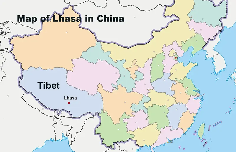 Map of Lhasa in China
Lhasa District Map: Surrounding Counties and Administrative Regions in Tibet
In terms of administrative divisions, Lhasa city comprises several urban districts and surrounding counties, including three municipal districts (the central urban and suburban areas) and five outlying rural counties.
The 3 Central Municipal Districts of Lhasa
These three areas form the urbanized core of Lhasa, lining the banks of the Lhasa River.
Chengguan District
Chengguan District is also Lhasa Urban District. It serves as the city's historical and political hub and is home to key landmarks such as the Potala Palace, Jokhang Temple, and Barkhor Street. On a tourist map, this area represents the essential must-visit zone, concentrating all of the city's classic attractions.
In Chengguan District, you can easily explore multiple landmarks on foot and immerse yourself in a rich Tibetan cultural atmosphere. It also offers the widest range of accommodation options, spanning everything from budget-friendly hotels to high-end establishments.
Doilungdêqên District
Located northwest of Lhasa's city center, the Doilungdêqên District includes the Lhasa Railway Station and several modern transport hubs. As the first stop for many travelers upon arrival, it serves as a vital gateway to the city.
Dagzê District
Dagzê District lies east of Lhasa’s urban area, situated in the transitional zone between the city and the rural, mountainous areas. Compared to the city center, it is quieter and offers expansive natural scenery alongside the charm of traditional Tibetan villages. It is also home to the renowned Ganden Monastery and Drak Yerpa Monastery.
The 5 Surrounding Counties of Lhasa
Expanding outward on the regional map brings you to the other five rural counties.
Damxung County
Located north of Lhasa, Damxung County offers vistas of grazing herds of yaks and sheep set against expansive meadows - a landscape characteristic of the pastoral regions of northern Tibet- and serves as a gateway for travelers heading to Namtso Lake.
Nyêmo County
Nyêmo County, in the southwest of Lhasa, is best known for its rich tradition of handicrafts - particularly the arts of making Tibetan incense and Tibetan paper, serving as a vital window into traditional Tibetan culture. Additionally, the county preserves certain traditional metalworking techniques and local folk customs.
Qüxü County
Qüxü County is in the southern part of Lhasa City, situated at the confluence of the Lhasa River and the Yarlung Tsangpo River. It connects urban Lhasa with the southern and western regions of Tibet. It is also the location of Drolma Lhakhang.
Maizhokunggar County
Maizhokunggar County, in the easternmost part of Lhasa City, connects to Nyingchi. It is a key area along vital transportation routes, the Sichuan-Tibet Highway and the Lhasa-Nyingchi Expressway; here, you can also visit Drikung Thil Monastery.
Lhünzhub County
Lhünzhub County is in the northeastern part of Lhasa, renowned for its natural scenery and traditional pastoral culture. The area features vast highland grasslands. Here, you will have the opportunity to gain firsthand insight into the local herders' way of life and experience rich Tibetan folk culture.
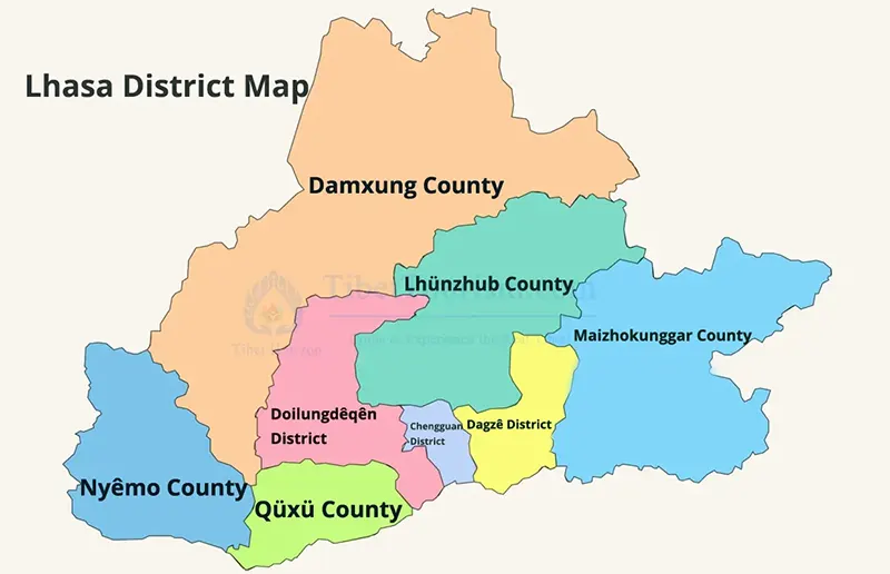 Lhasa District Map
Map of Lhasa Surrounding Cities and Prefectures in Tibet
Beyond Lhasa, Tibet encompasses several other important regions that are home to renowned attractions such as Everest Base Camp, Changtang Grasslands, and Mount Kailash.
Shigatse - Home to Everest Base Camp
Shigatse is the second-largest city in Tibet and a necessary stop on the way to Everest Base Camp. The route from Lhasa to EBC passes by Yamdrok Lake and Karola Glacier, making it one of the most popular travel itineraries in Tibet.
Nyingchi - The Switzerland of Tibet
Nyingchi is renowned for its peach blossoms, forests, and lush vegetation. Compared to other parts of Tibet, it boasts a lower altitude and a milder climate, hailed as “Tibet's Switzerland”; a Nyingchi tour is also a popular choice to begin for many travelers visiting Tibet for the first time.
Nagqu - Gateway to Northern Tibet
With an average elevation exceeding 4,500 meters, Nagqu is home to the vast, boundless Changtang Grasslands. It is also a key transit point on the route to Lhasa; whether you travel along Qinghai-Tibet Railway or National Highway G109, you will pass through this expansive grassland.
Shannan - Cradle of Tibetan Civilization
Shannan is considered a vital birthplace of Tibetan culture and is home to numerous historical landmarks, including Samye Monastery - Tibet's first monastery and the Yumbulakhang Palace. It is also a key transit point that travelers can hardly bypass, as Lhasa Gonggar Airport is here.
Ngari - Land of Mount Kailash
Ngari Prefecture, located in the westernmost part of Tibet, though far from Lhasa, is the ultimate destination for many adventurers. Many tourists choose to embark on an unforgettable Kailash Mansarovar tour here.
Chamdo - Eastern Gateway to Tibet
Chamdo is a crucial gateway to Tibet via the Sichuan-Tibet Highway and the Yunnan-Tibet Highway. It boasts stunning scenery of eastern Tibetan valleys, diverse ethnic cultures, and magnificent mountain landscapes, attracting many tourists who choose to drive or cycle.
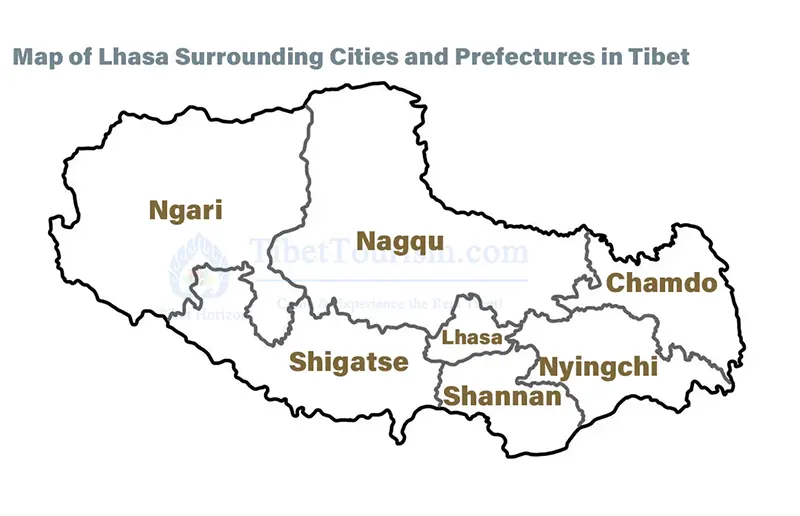 Map of Lhasa Surrounding Cities and Prefectures in Tibet
Map of Lhasa and Surrounding Provinces in China
Because Tibet is located in southwestern China, bordering the Xinjiang Autonomous Region, Qinghai Province, Yunnan Province, and Sichuan Province, these provinces provide convenient transportation options to Lhasa.
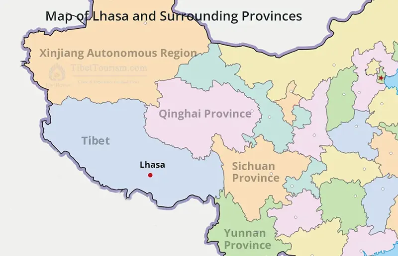 Map of Lhasa and Surrounding Provinces in China
Map of Tibet Lhasa and Surrounding Countries in the World
Tibet is located on the northern slopes of the Himalayas, bordering Asian countries such as Nepal, India, Bhutan, and Myanmar. Therefore, we have designed a series of Tibet tours related to these countries, such as thrilling journeys from Nepal to Tibet , trips from Bhutan to Tibet, or starting your Tibet tour from Myanmar - all with Tibet travel packages to suit your various needs.
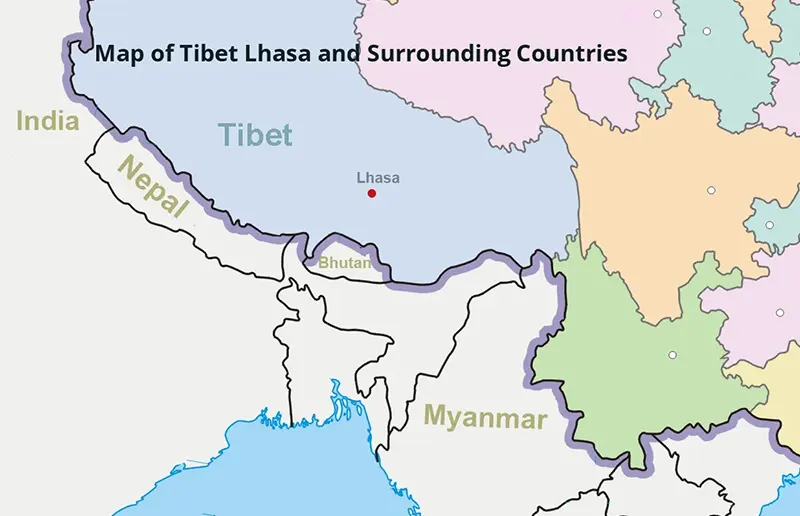 Map of Tibet Lhasa and Surrounding Countries in the World
Tibet Lhasa Flight Map
For most tourists, taking a flight is the fastest and most convenient way to Lhasa. The choices of departure cities are quite diverse, including Beijing, Shanghai, nearby Chengdu, and even the vibrant city of Kathmandu, all of which offer direct flights to Lhasa. If you choose a suitable flight time, you might even enjoy breathtaking aerial views of Mount Everest during your Tibet flight tour.
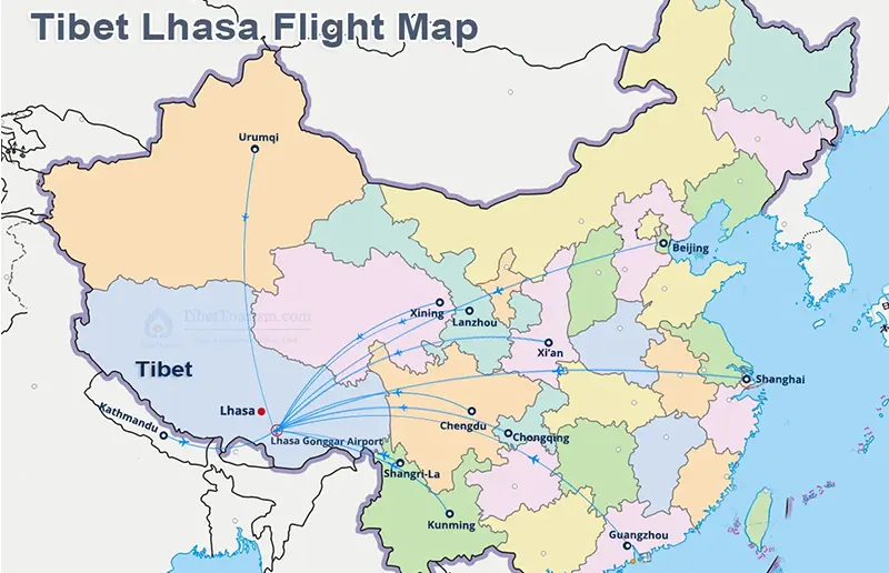 Tibet Lhasa Flight Map
Tibet Lhasa Train Map
Besides taking a flight, you can also take the world-famous Tibet train to Lhasa. This train route connects to many major cities in China, with departures from Beijing, Shanghai, Guangzhou, Chengdu, Chongqing, Xi'an, Lanzhou, and Xining. Along the way, you can enjoy views of snow-capped mountains, grasslands, and lakes before arriving in Lhasa. Also, Xining is the starting point of the Qinghai-Tibet Railway and offers the shortest journey and the most frequent train services to Lhasa. If you cannot purchase train tickets from other cities, consider arriving in Xining first and then continuing your Tibet train tour.
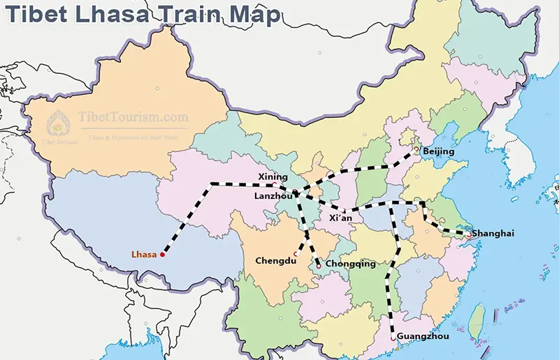 Tibet Lhasa Train Map
Tibet Lhasa Road Map
If you have ample travel time and wish to experience a more thrilling road trip, that's also possible. National highways from Sichuan, Yunnan, Qinghai, Xinjiang, and even Nepal all lead directly to Lhasa. Whether you choose a self-driving tour, a chartered trip, a cycling or motorbike adventure, an overland adventure is waiting for you.
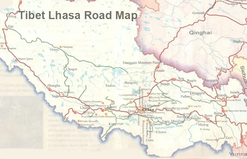 Tibet Lhasa Road Map
Conclusion
The various Lhasa maps above will help you understand Lhasa's location, from world maps and China maps to Tibet's administrative division map, city routes, air routes, railways, and highway networks. You can gain a comprehensive understanding of its connections to other destinations.
If you are planning a Lhasa tour, why not choose to travel with Tibet Horizon? With our knowledge of Lhasa, we are confident that your journey will be safe and unforgettable.
8 years exp.| 5.0
 | Reviews
Tell me about your travel plan or contact me via inquiry@tibettourism.com
Related Tibet Travel Guide and Advice


Most Popular Tibet Tour Packages
-
![Holy Lhasa City Small Group Tour]() Small Group Tour
Small Group Tour4 Days Holy Lhasa City Small Group Tour
Promo: Explore the Architecture & Landscape of Lhasa
Dates & Price
![rili]()
![xiala]()
-
![Lhasa Yamdrok Shigatse Central Tibet Culture Small Group Tour]() Small Group Tour
Small Group Tour6 Days Lhasa Yamdrok Shigatse Central Tibet Culture Small Group Tour
Promo: Taste the essence of Tibetan Culture in central Tibet
Dates & Price
![rili]()
![xiala]()
-
![8 Days Lhasa Yamdrok Mount Everest Base Camp Join-in Group Tour]() Real Join-in Group Tour
Real Join-in Group Tour8 Days Lhasa Yamdrok Mount Everest Base Camp Join-in Group Tour
Promo: Comprehensive Trip to Discover Tibet’s Magic
Dates & Price (More Traveler, Lower Price)
![rili]()
![xiala]()


Please share your contact information, so we can send you the answer directly by email.

