
 inquiry@tibettourism.com


.webp)


Tibet Everest Base Camp Trek Map


.webp) Content
ContentEverest Base Camp in Tibet is located on the north side of Mount Everest at an altitude of approximately 5,200 meters. There are two main classic routes for trekking in the Mount Everest region: the 4-day Old Tingri trek and the 8-day Gama Valley trek. Compared to the south base camp in Nepal, the Tibetan route is more accessible and ideal for travelers seeking a more time-efficient EBC trekking experience. With this Everest Base Camp trek map, you can easily view the daily trekking route, key stops, and elevation changes. Continue reading to plan a safe and memorable Tibet EBC tour.
| Feature | Tibet Everest Base Camp (North Face) | Nepal Everest Base Camp (South Face) |
|---|---|---|
| Location | Tibet, China | Nepal |
| Altitude | 5,200 m | 5,364 m |
| Trekking Duration Only | 4 days (Old Tingri) or 8 days (Gama Valley) | Typically 12–14 days |
| Distance | 70 km (Old Tingri) or 110 km (Gama Valley) | Approx. 130 km (Lukla to EBC and back) |
| Difficulty | Easy to moderate | Moderate to challenging |
| Best Time | April–May, September–October | March–May, October–November |
| Feature | Tibet Everest Base Camp (North Face) | Nepal Everest Base Camp (South Face) |
|---|---|---|
| Location | Tibet, China | Nepal |
| Altitude | 5,200 m | 5,364 m |
| Trekking Duration Only | 4 days (Old Tingri) or 8 days (Gama Valley) | Typically 12–14 days |
| Distance | 70 km (Old Tingri) or 110 km (Gama Valley) | Approx. 130 km (Lukla to EBC and back) |
| Difficulty | Easy to moderate | Moderate to challenging |
| Best Time | April–May, September–October | March–May, October–November |
Where Is the Everest Base Camp in Tibet?
Everest Base Camp in Tibet is located on the northern side of Mount Everest in Tingri County, Shigatse City, at an altitude of about 5,200m. Known as the North Everest Base Camp, it offers spectacular views of the world's highest mountain and is one of the most popular destinations for a Tibet EBC tour.
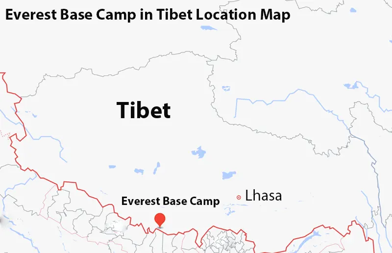 Tibet Everest Base Camp Location Map
Where Does the Everest Base Camp Trek Start on the Map?
The classic Everest Base Camp trek in Tibet starts from Old Tingri, while adventurous trekkers can explore the Gama Valley route on the eastern side of Mt. Everest.
Old Tingri (Gangga Town, Dingri County, Shigatse City)
Situated at an altitude of about 4,300 meters, Old Tingri serves as the main gateway for travelers embarking on the Everest Base Camp trek in Tibet. From here, you can follow the classic route that passes through scenic valleys, high-altitude plains, and local Tibetan villages, eventually reaching the Everest Base Camp.
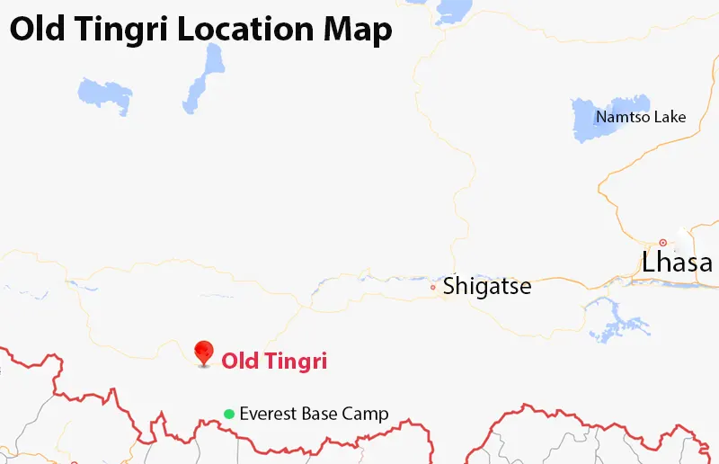 Old Tingri Location Map
Youpa Village (Kharta Region, Dingri County, Shigatse City)
Situated at a lower altitude of about 3,770 meters compared to Old Tingri, Youpa Village enjoys relatively richer vegetation. The village is the official starting point for the trekking route from Gama Valley to eastern face of Mt. Everest in Tibet.
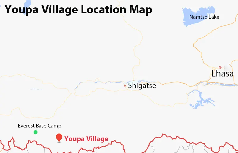 Youpa Village Location Map
How to Reach the Everest Base Camp Trek Starting Point?
Reaching Old Tingri or Youpa Village requires careful planning due to the vast distances across the Tibetan Plateau. You usually travel from Lhasa or the Chinese Mainland to Old Tingri or Youpa Village via Shigatse.
Lhasa to Old Tingri or Youpa Village via Shigatse
There are various modes of transportation available from Lhasa. You can travel from Lhasa to Shigatse by train, road, or bicycle, and then proceed by land to Old Tingri. Among these options, the most common route is Lhasa to Old Tingri or Youpa Village by road.
Chinese Mainland to Old Tingri or Youpa Village via Shigatse
Travelers from the Chinese Mainland (such as Chengdu, Xi'an, or Chongqing) can fly directly to Shigatse Peace Airport or Shigatse Tingri Airport. From there, you continue by road to Old Tingri or Youpa Village. This route combines "fly and drive," offering a fast option for those planning an Everest Base Camp trek.
Everest Base Camp Trek Route Map: Distance, Elevation, and Duration
Understanding the precise topography and route of your journey is the first step to a successful Himalayan adventure. A detailed map of the Old Tingri to Everest Base Camp trek distance, elevation, and duration will serve as your first blueprint. It visualizes how the miles and campsites are distributed across Tibet's high-altitude terrain. By analyzing the map’s key waypoints, you can easily pace yourselves and make the necessary adjustments required for a safe EBC trek.
1) How Long Is the Everest Base Camp Trek?
The trekking distance from Old Tingri to Everest Base Camp is about 70 kilometers. The total hiking distance from Youpa Village is approximately 110 kilometers. These routes pass through high-altitude valleys, Tibetan villages, and open plains, gradually ascending to the EBC. They are shorter and less strenuous than the classic Nepal to Everest Base Camp trek route, making it suitable for a wider range of travelers.
2) How High is the Everest Base Camp Trek?
The Everest Base Camp trek elevation features a dramatic high-altitude arc. The journey starts at Old Tingri (4,300m) and steadily climbs to its ultimate destination at the Everest Base Camp (5,200m). The highest and most physically demanding geographic marker on the map is Lamna La (5,150m). If your itinerary begins at Youpa Village (3,770m), you will cross Nangma-la (5,344m) during the trek.
3) How Many Days for Everest Base Camp Trek?
The trek from Old Tingri to Everest Base Camp typically takes 4 days. The other route requires an 8-day hike. If you opt for an EBC trek private tour, the overall duration can be customized based on your acclimatization needs. This duration includes acclimatization stops at Old Tingri, Shigatse, and nearby villages to help travelers adjust to the high altitude. Proper pacing and planning ensure a safe, enjoyable, and memorable Everest Base Camp trek in Tibet.
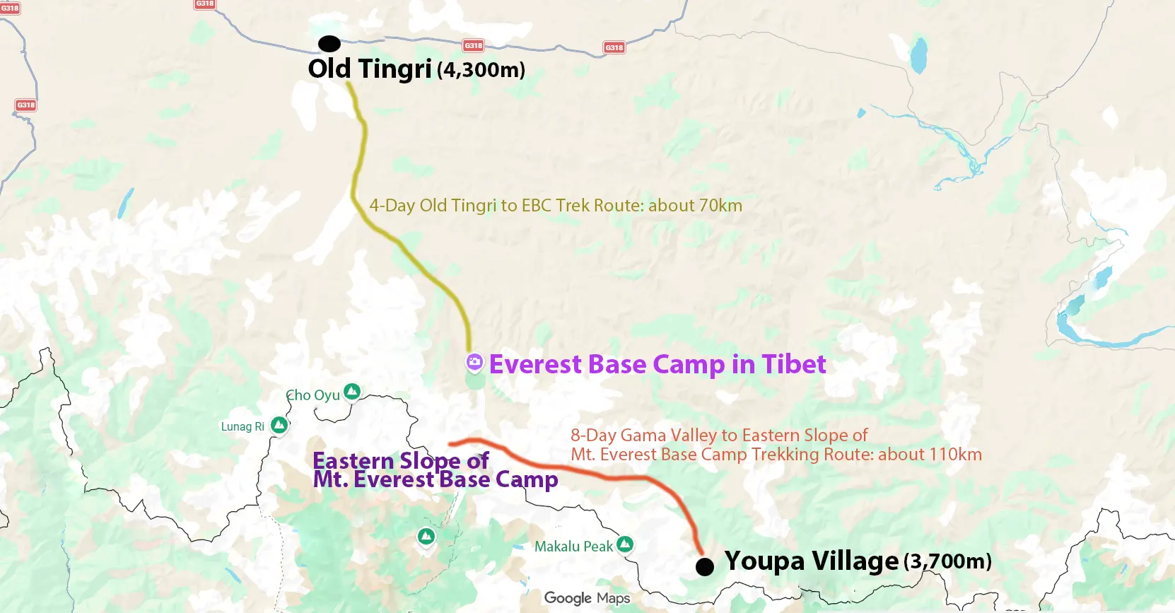 Everest Base Camp Trek Route Map
Complete Day-to-Day Everest Base Camp Trek Itinerary Map
To help you navigate the 70-kilometer or 110-kilometer trek successfully, our day-to-day Everest Base Camp trek itinerary maps break down the two journeys into the following walking stages.
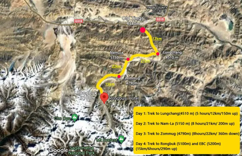
Old Tingri to Everest Base Camp Trekking Route on Map
Day 1: Old Tingri to Lungjiang
Distance: 12km
Trekking Time: 5 hours
Elevation Change: 4,300m to 4,510m
Accommodation: Camping
The trek begins in Old Tingri, the starting point of the classic Everest Base Camp trek in Tibet. The route crosses open grasslands and offers distant views of the Himalayan peaks.
Day 2: Lungjiang to Lamna La Pass
Distance: 21km
Trekking Time: 8 hours
Elevation Change: 4,510m to 5,150m
Accommodation: Camping
This is the most challenging day of the trek. Travelers ascend to Lamna La Pass, the highest point on the route, and enjoy spectacular views of Mount Everest, Cho Oyu, and Shishapangma.
Day 3: Lamna La Pass to Zombuk/Chaya Pass
Distance: 22km
Trekking Time: 8 hours
Elevation Change: 5,150m to 4,790m
Accommodation: Camping
The trail descends gradually through remote valleys and traditional Tibetan grazing areas. The route offers excellent opportunities to experience the unique scenery of the Tibetan Plateau.
Day 4: Zombuk/Chaya Pass to Rongbuk and Everest Base Camp
Distance: 15km
Trekking Time: 6 hours
Elevation Change: 4,790m to 5,200m
Accommodation: Camping
The final day leads to Everest Base Camp. Upon arrival, trekkers can enjoy breathtaking views of the north face of Mount Everest and visit the nearby Rongbuk Monastery, the highest monastery in the world.
Recommended Itinerary:
10-day Old Tingri to Everest Base Camp trek tour
 Old Tingri to Everest Base Camp Trek Map
Gama Valley to Eastern Slope of Mt. Everest Base Camp Trekking Route on Map
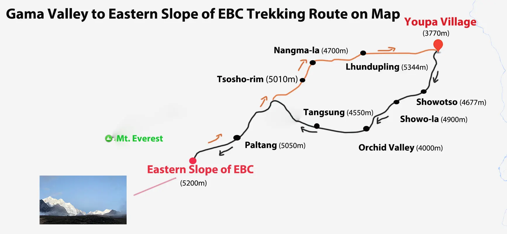
Day 1: Youpa Village to Showotso
Distance: 10km
Trekking Time: 6 hours
Elevation Change: 3,770m to 4,800m
Accommodation: Camping
Today marks the official start of the trek to Gama Valley on the eastern slope of Mount Everest. You will gather at Youpa Village, where a guide will lead the group as you set off with light packs.
Day 2: Showotso to Orchid Valley via Showo-la
Distance: 14km
Trekking Time: 7-8 hours
Elevation Change: 4,800m to 4,900m to 4,000m
Accommodation: Camping
Today, you will cross the first major challenge: the Showo-la, situated at an altitude of 4,900 meters. In clear weather, you can enjoy magnificent distant views of Mount Makalu and Lhotse from this vantage point. After crossing the pass, the trail descends steeply, eventually leading to the Orchid Valley (Dolshang) campsite.
Day 3: Orchid Valley to Tangsung Viewpoint
Distance: 12 km
Trekking Time: 5-6 hours
Elevation Change: 4,000m to 5,000m
Accommodation: Camping
Today, you will ascend the valley, passing through primeval forests and alpine meadows. As the landscape opens up, you will finally reach the Tangsung Viewpoint, where you can witness a breathtaking sunset over the East Face of Mount Everest, Lhotse, and Makalu.
Day 4: Tangsung Viewpoint to Paltang
Distance: 6km
Trekking Time: 3-4 hours
Elevation Change: 5,000m to 5,050m
Accommodation: Camping
Today's journey will be a gentle ascent starting from Tangsung Viewpoint. The route traverses scree slopes and alpine meadows, eventually reaching Paltang, a location closer to the East Face of Mount Everest.
Day 5: Paltang Loop Tour via Eastern Face of Mt.Everest and Rabga
Distance: 18 km
Trekking Time: 7-8 hours
Elevation Change: 5,050m to 5,200m to 5,050m
Accommodation: Camping
Today marks the absolute highlight of the entire journey. Along the way, you will hike and get up close to the breathtaking glacial scenery of the east face of Everest.
Day 6: Paltang to Tangsung
Distance: 11km
Trekking Time: 5 hours
Elevation Change: 5,050m to 5,000m
Accommodation: Camping
Today marks the official start of the return journey. Along the way, the route winds once more through the magnificent Gama Valley before finally reaching Tangsung. From this vantage point, you can look back and take in the sweeping silhouettes of the 8,000-meter peaks once again.
Day 7: Tangsung to Tsosho-rim
Distance: 11km
Trekking Time: 5-6 hours
Elevation Change: 5,000m to 5,010m
Accommodation: Camping
Today’s journey culminates at the shores of Tsosho-rim, situated at an altitude of over 5,000 meters. This is the ultimate, unrivaled spot for photographing the reflections of Mount Everest, Lhotse, and Makalu.
Day 8: Tsosho-rim to Lhundupling via Nangma-la
Distance: 16 km
Trekking Time: 7-8 hours
Elevation Change: 5,010m to 5,344m to 4,700m
Accommodation: Camping
Today, the trek begins at Tsosho-rim and heads toward Nangma-la, located at an altitude of 5,344 meters. After crossing the pass, you will arrive at Lhundupling Village in the afternoon. Finally, departing from Lhundupling, you will return to Lhasa via famous attractions such as Everest Base Camp and Tashilhunpo Monastery.
Recommended Itinerary:
15-day Tibet Mount Everest Gama Valley trekking tour
 Gama Valley to Eastern Slope of Mt. Everest Base Camp Trekking Route on Map
Conclusion
The Everest Base Camp trek in Tibet offers an unforgettable journey through stunning Himalayan landscapes. With well-planned routes, essential maps, and acclimatization stops, you can safely explore the Tibetan Everest region. This EBC trek is perfect for adventure seekers and those looking to experience Tibet’s high-altitude beauty.
10 years exp.| 5.0
 | Reviews
Tell me about your travel plan or contact me via inquiry@tibettourism.com
Tibet Everest Travel Guide and Advice


Most Popular Tibet Everest Tour Packages
-
![Old Tingri to Everest Base Camp Trek Small Group Tour]() Small Group Tour
Small Group Tour10 Days Old Tingri to Everest Base Camp Trek Small Group Tour
Promo: Embark on the ultimate trekking adventure to Mount Everest Base Camp.
Dates & Price
![rili]()
![xiala]()
-
![12 Days Tibet Classic Trek from Old Tingri to Everest Base Camp Tour]()
12 Days Tibet Classic Trek from Old Tingri to Everest Base Camp Tour
Features:
Suitable for first-time hikers
Classic EBC trekking route
Vast pastures and lush valleysGroup size: Min.1 pax
Tour price: free enquire >
-
![Tibet Mount Everest Garma Valley Trekking Small Group Tour]() Shared Group Tour
Shared Group Tour15 Days Tibet Mount Everest Garma Valley Trekking Small Group Tour
Promo: World's most beautiful valley & 1 of top 10 trekking routes
Dates & Price
![rili]()
![xiala]()


Please share your contact information, so we can send you the answer directly by email.

