
 inquiry@tibettourism.com


.webp)


Lhasa Maps: Location Map, City Map, Administrative Map, Tourist Map, Transportation Map


.webp) Content
ContentHaving been the capital city of Tibet since the seventh century, Lhasa is world-renown for its beautiful scenery, rich history, customs with its own characteristics, and diverse religions. With an altitude of 3,650m above sea level, Lhasa City is one of the highest cities in the world with so many natural attractions and spiritual sites to offer. The old city of Lhasa, with Jokhang Temple as the center, has gone through more than 1300 years of changes, becoming the essence of Tibetan culture.
Lhasa Location Map
Located in the center part of the Tibet Autonomous Region, Lhasa can be found at the north bank of the Brahmaputra River. It borders Nagqu Prefecture to the north, Nyingchi Prefecture to the east, Shannan Prefecture to the south and Shigatse Prefecture to the west. It enjoys a total area of 29,500 square kilometers, with a population of 867,891.
 Lhasa Location Map
Lhasa City Map
Lhasa City is 29,500 square kilometers in area. And Lhasa River flows through Lhasa City, which makes Lhasa more beautiful. If you want to know the layout of Lhasa City and know the basic buildings and streets inside the city, you can check the map below.
Lhasa Administrative Map
Lhasa administrates 3 districts and 5 counties, namely Chengguan District, Duilong Deqen District, Dagze District, Nyemo County, Damxung County, Lhinzhub County, Quxu County, and Mozhugongka County. And there are four new functional zones in Lhasa.
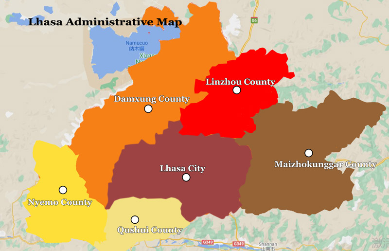 Lhasa Administrative Map
Lhasa Tourist Map
Lhasa is not only the capital city of Tibet Autonomous Region, but also the political, economic and cultural center of Tibet. Tourists come here will get the chance to enjoy those scenic and historical sites in Lhasa, including those world-famous Potala Palace, Jokhang Temple, Drepung Monastery, Sera Monastery, and Ganden Monastery. For most tourists in this world, Lhasa is definitely one of the most unique and the most charming city in their mind. Everyone will be amazed at its beautiful scenery, long history, splendid culture, local conditions and customs with local characteristics, numerous scenic spots and historical sites, etc.
 Lhasa Tourist Map
Lhasa Transportation Map
Currently, tourists can get to Lhasa by plane or by train. Cities that connect with Lhasa include Beijing, Shanghai, Guangzhou, Chengdu, Chongqing, Xi'an, Xining, and some other major cities in China. You can check more detailed information on our site or contact us for more updated information to arrange your Tibet tour. However, tourists can also choose to get to Lhasa by overland tour via Qinghai Tibet Highway, Sichuan Tibet Highway, Yunnan Tibet Highway, Xinjiang Tibet Highway and Sino-Nepal Friendship Highway.
 Lhasa Transportation Map
5 years exp.| 5.0
 | Reviews
Tell me about your travel plan or contact me via inquiry@tibettourism.com
Related Tibet Travel Guide & Advice


Most Popular Tibet Tour Packages
-
![15 Days Lhasa EBC Kailash Mansarovar Gyirong Sakya Shigatse Lhasa Join-in Group Tour]() Real Join-in Group Tour
Real Join-in Group Tour15 Days Lhasa EBC Kailash Mansarovar Gyirong Sakya Shigatse Lhasa Join-in Group Tour
Promo: Journey through the Himalayan mountains and lakes to uncover their mysteries
Dates & Price (More Traveler, Lower Price)
![rili]()
![xiala]()


Please share your contact information, so we can send you the answer directly by email.

