
 inquiry@tibettourism.com








Map of Roads to Lhasa: Routes from Sichuan, Yunnan, Qinghai, Xinjiang, Nepal, and Other Tibetan Regions
Having an overland tour to Tibet is different from getting into Tibet by train or flight. It will show you things that you would never get the chance to see from a train or plane. And you can stop whenever and wherever you want to take photos or stay for a while to enjoy the breathtaking scenery along the road. You can choose to enter Tibet by roads from Chinese Mainland, Nepal or other Tibet regions. Here are the latest maps of roads to Tibet.
From the Chinese Mainland, there are a total of 4 highways available for tourists who want to take an overland tour to Tibet: the Qinghai-Tibet Highway from Xining to Lhasa, the Sichuan-Tibet Highway from Chengdu to Lhasa, the Yunnan-Tibet Highway from Kunming to Lhasa, and the Xinjiang-Tibet Highway from Kashgar to Lhasa. Those highways are the most important roads that make it possible for Tibet to connect the outside world at the end of last century. Besides, if you want to travel overland from Kathmandu, Nepal, the Sino-Nepal Friendship Highway can take you to Lhasa via Zhangmu Port. Within Tibet, highways and regional roads connect Nyingchi, Shigatse, Shannan, Nagqu, Ngari, and Chamdo with Lhasa.
Maps of Roads from Shigatse, Ngari, Nyingchi, Shannan, Nagqu, and Chamdo to Lhasa
Lhasa is connected to other parts of Tibet by a network of highways and regional roads. These journeys reveal diverse landscapes, from forested valleys and river plains to vast grasslands and remote high-altitude terrain. The following maps show the main roads from six regions to Lhasa.
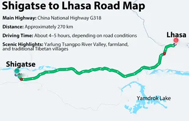
Shigatse to Lhasa Road Map
China National Highway G318 connects Shigatse with Lhasa. The approximately 270 km drive takes about 4–5 hours, depending on the route and road conditions. Travelers can enjoy views of the Yarlung Tsangpo River valley, farmland, and traditional Tibetan settlements along the way.
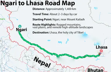
Ngari to Lhasa Road Map
The road journey from Ngari to Lhasa covers nearly 1,400 km across western Tibet and takes about 2–3 days. Starting near sacred Mount Kailash, the route crosses rugged mountains, vast plains, and remote high-altitude landscapes before reaching the holy city of Lhasa.
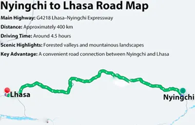
Nyingchi to Lhasa Road Map
The G4218 Lhasa–Nyingchi Expressway connects Nyingchi with Lhasa over a distance of approximately 400 km. The drive takes around 4.5 hours, passing through forested valleys and mountainous landscapes. It provides a convenient road connection between eastern Tibet and the capital.
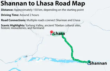
Shannan to Lhasa Road Map
Shannan lies southeast of Lhasa, approximately 150 km away, depending on the starting point. Several roads connect the two regions, and the drive may take around two hours. Along the way, travelers can explore the Yarlung Valley, known for its ancient Tibetan cultural sites, historic monasteries, and agricultural landscapes.
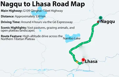
Nagqu to Lhasa Road Map
The G109 Qinghai–Tibet Highway connects Nagqu with Lhasa. Stretching approximately 330 km across the Northern Tibetan Plateau, this high-altitude drive takes about 4 hours via the G6 expressway. You can see vast pastures, grazing animals, and expansive plateau scenery along the way.
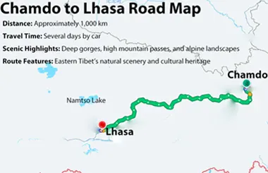
Chamdo to Lhasa Road Map
Chamdo to Lhasa overland journey covers roughly 1,000 km across eastern Tibet and takes several days. The route winds through deep gorges, high mountain passes, and alpine landscapes, offering a glimpse of the region’s natural beauty and cultural heritage.
- Lhasa Maps: Location Map, City Map, Administrative Map, Tourist Map, Transportation Map
- Shigatse Maps: Essential Location, Tourist & Transport Guide
- Ngari Maps: Location, Administrative & Travel Maps
- Nyingchi Maps: Location Map, Tourist Map, Administrative Map, Transportation Map
- Shannan Maps: Location, Tourist, Administrative & Road Maps
- Nagqu Maps: Location Map, Tourist Map, Transportation Map
Maps of Roads from Sichuan, Qinghai, Xinjiang, Yunnan, and Nepal to Lhasa
Map of Sichuan-Tibet Highway G318 & G317
The Sichuan-Tibet Highway is divided into two routes: the northern route and the southern route. The northern route covers a length of 2,412 km, with Que'er Mountain as its highest point, while the southern route covers 2,146 km. No matter which route you choose for your Tibet overland tour from Chengdu, you will never regret it, as the scenery along the way will definitely amaze you. The northern route opened in December 1954, while the southern route officially opened in 1969. The section from Chengdu to Xinduqiao and the section from Bamda to Lhasa overlap. Thousands of soldiers lost their lives during the construction of the highway because of the difficult terrain and complex geographical conditions along the route. Thus, the Sichuan-Tibet Highway marked a milestone in Tibet's development by connecting the region with the Chinese Mainland. It is also an important route for tourists from Sichuan and the surrounding areas to travel to Tibet.
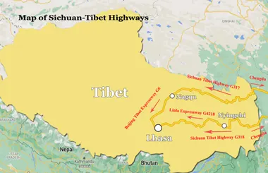
Map of Sichuan-Tibet Highway G318 & G317
Chamdo to Lhasa overland journey covers roughly 1,000 km across eastern Tibet and takes several days. The route winds through deep gorges, high mountain passes, and alpine landscapes, offering a glimpse of the region’s natural beauty and cultural heritage.
No documents found.
Map of Qinghai-Tibet Highway G109
The Qinghai-Tibet Highway runs from Xining in Qinghai to Lhasa in Tibet, covering 1,347 km in total. It is one of the highest and longest roads in the world, connecting Tibet with the outside world since 1954, after four years of tough construction. This route is the busiest and also the shortest road from the Chinese Mainland to Tibet, with a lot of picturesque views along the way, including vast grasslands, salt lakes, the Gobi Desert and high-altitude wilderness. If you join a Xining to Tibet tour, you will get the chance to have a close look at famous tourist spots, such as Qinghai Lake, Kunlun Mountain Pass, Hoh Xil National Nature Reserve, Tuotuo River, Tanggula Pass, Amdo Grassland, and Namtso.
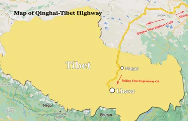
Qinghai-Tibet Highway G109 Map
The map of the Qinghai-Tibet Highway (G109) shows the main route from Xining to Lhasa and the key stops along the way. It helps you understand the route and locate major attractions, mountain passes, and scenic landscapes along the journey.
No documents found.
Map of Xinjiang-Tibet Highway G219
With an average altitude of over 4,500 meters, the Xinjiang-Tibet Highway is also one of the highest roads in the world. Opened to traffic in 1957, it is a vital route for entering Tibet. It starts from Yecheng in Xinjiang and ends in Lhatse in Tibet, covering a total length of 2,140 km. You can encounter many uninhabited areas along the road from Xinjiang to Tibet. However, joining a tour from Xinjiang to Tibet will be an amazing experience for adventurous tourists. Just be careful, and it is highly recommended to prepare all the necessary supplies for expected and unexpected situations when passing through these remote areas.
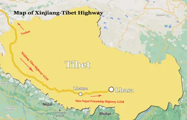
Map of Xinjiang-Tibet Highway G219
The map of the Xinjiang-Tibet Highway (G219) shows the route from Yecheng in Xinjiang to Lhatse in Tibet. It helps you locate major mountain passes, remote areas, and scenic landscapes along this high-altitude journey.
No documents found.
Map of Yunnan-Tibet Highway G214
The Yunnan-Tibet Highway, also known as Highway No. 214, is another important road that connects Kunming and Lhasa. It covers a total length of 1,930 km, serving as a bridge that brings tourists from Yunnan to Tibet. It does not pass through many high-altitude areas, but tourists need to drive for 39 km at altitudes of more than 4,000 m and for 239 km at altitudes between 3,000 m and 4,000 m. So, it is also a tough and adventurous journey due to the challenging terrain, which includes numerous snow-capped mountains, tunnels, bridges, etc. The Yunnan-Tibet Highway is known as one of the most dangerous yet beautiful roads to Tibet, attracting many tourists who want to experience this Kunming to Tibet tour.
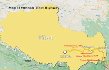
Map of Yunnan-Tibet Highway G214
The map of the Yunnan-Tibet Highway (G214) shows the route from Kunming to Lhasa through Yunnan and eastern Tibet. It helps you locate major towns, mountain passes, and scenic landscapes along the journey.
No documents found.
Map of Sino-Nepal Friendship Highway G318
The Sino-Nepal Highway is an international road that links Tibet with Kathmandu, attracting thousands of international tourists who travel along this road from Tibet to Nepal or vice versa. It starts from Lhasa and passes through Shigatse and Lhatse County before splitting into two routes. The eastern route leads to Zhangmu Port and continues to Kathmandu via the Friendship Bridge, while the western route takes tourists to Kathmandu via Gyirong Port. (Gyirong Port has remained closed since the mudslide in August 2026.) The section of the road in Tibet is well-paved, allowing tourists to travel comfortably by car. However, tourists need to pay attention to speed limits and put safety first. Along the Sino-Nepal Highway, a Tibet Nepal tour can include highlights such as Yamdrok Lake, Karola Glacier, Tashilhunpo Monastery, Sakya Monastery, Mt. Everest, Rongbuk Monastery, etc.
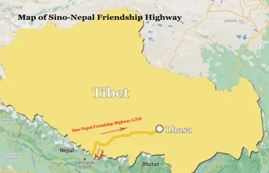
Map of Sino-Nepal Friendship Highway G318
The Sino-Nepal Friendship Highway forms a scenic section of National Highway G318, connecting Lhasa in Tibet to the Nepal border. The map helps you locate major attractions, mountain passes, and border crossings along the journey.
No documents found.
No documents found.
No documents found.
No documents found.
Most Classic Tibet Tour Packages
Explore Tibet with our most classic tour packages, featuring iconic landmarks, stunning natural landscapes, and rich Tibetan culture. From the historic Potala Palace in Lhasa to the breathtaking views of Mount Everest and the sacred Mount Kailash, these tours offer unforgettable experiences for every traveler. Choose your ideal itinerary and discover the best of Tibet at your own pace.
-
![Holy Lhasa City Small Group Tour]() Small Group Tour
4 Days Holy Lhasa City Small Group Tour
Promo: Explore the Architecture & Landscape of Lhasa
Dates & Price
![rili]()
![xiala]()
-
![Lhasa Shigatse Mount Everest Small Group Tour]() Small Group Tour
8 Days Lhasa Shigatse Mount Everest Small Group Tour
Promo: Once-in-a-lifetime chance to face the tallest mountain in the world
Dates & Price
![rili]()
![xiala]()
-
![Lhasa to Everest Kailash and Mansarovar Small Group Tour]() Small Group Tour
15 Days Tibet Mount Kailash and Lake Mansarovar Small Group Tour
Promo: Western Tibet tour around Mount Kailash
Dates & Price
![rili]()
![xiala]()
-
![Lhasa Yamdrok Shigatse Central Tibet Culture Small Group Tour]() Small Group Tour
6 Days Lhasa Yamdrok Shigatse Central Tibet Culture Small Group Tour
Promo: Taste the essence of Tibetan Culture in central Tibet
Dates & Price
![rili]()
![xiala]()
-
![Lhasa Shigatse Everest Base Camp Namtso Small Group Tour]() Small Group Tour
9 Days Lhasa Shigatse Everest Base Camp Namtso Small Group Tour
Promo: Unveil the profound spirituality and natural beauty that lie within the heart of Tibet.
Dates & Price
![rili]()
![xiala]()
-
![Lhasa Everest Kailash Mansarovar Guge Kingdom Full Moon Small Group Tour]() Small Group Tour
17 Days Lhasa Everest Kailash Mansarovar Guge Kingdom Full Moon Small Group Tour
Promo: Explore western Tibetan spirituality and culture around the sacred Mount Kailash
Dates & Price
![rili]()
![xiala]()
-
![Lhasa Yamdrok Lake Small Group Tour]() Small Group Tour
5 Days Lhasa Yamdrok Lake Small Group Tour
Promo: Marvel at the Heavenly Lake - Yamdrok Lake
Dates & Price
![rili]()
![xiala]()
-
![Lhasa Namtso Lake Small Group Tour]() Small Group Tour
5 Days Lhasa Namtso Lake Small Group Tour
Promo: Expose the age-old spiritual wisdom and magnificent natural wonders that are concealed in the heartland of Tibet.
Dates & Price
![rili]()
![xiala]()
-
![Lhasa Ganden Monastery Drak Yerpa Small Group Tour]() Small Group Tour
5 Days Lhasa Ganden Monastery Drak Yerpa Small Group Tour
Promo: Reveal the deep-seated religious essence and stunning landscapes that exist within the core of Tibet
Dates & Price
![rili]()
![xiala]()
-
![Old Tingri to Everest Base Camp Trek Small Group Tour]() Small Group Tour
10 Days Old Tingri to Everest Base Camp Trek Small Group Tour
Promo: Embark on the ultimate trekking adventure to Mount Everest Base Camp.
Dates & Price
![rili]()
![xiala]()
-
![Tibet Nepal Bhutan Small Group Tour]() Small Group Tour
13 Days Tibet Nepal Bhutan Small Group Tour
Promo: Unveil the spiritual and natural mysteries concealed in the Himalayan Mountains.
Dates & Price
![rili]()
![xiala]()
-
![Kathmandu to Lhasa Overland Small Group Tour with EBC]() Small Group Tour
8 Days Kathmandu to Lhasa Overland Small Group Tour with EBC
Promo: Drive Across Himalaya Overland Tour with altitude rising slowly
Dates & Price
![rili]()
![xiala]()
-
![Lhasa Everest Base Camp Kathmandu Overland Small Group Tour]() Small Group Tour
7 Days Lhasa Everest Base Camp Kathmandu Overland Small Group Tour
Promo: Classic overland travel route from Lhasa to Kathmandu via Nyalam
Dates & Price
![rili]()
![xiala]()
-
![Lhasa Everest Kailash Mansarovar Zhangmu Kathmandu Small Group Tour]() Small Group Tour
12 Days Lhasa Everest Kailash Mansarovar Zhangmu Kathmandu Small Group Tour
Promo: Uncover the spiritual and natural secrets hidden within Tibet
Dates & Price
![rili]()
![xiala]()
-
![Lhasa Everest Kailash Mansarovar Lhasa Tour with Inner Travel Gateway]() Small Group Tour
16 Days Lhasa Everest Kailash Mansarovar Lhasa Tour with Inner Travel Gateway
Promo: Complete 3-Day Kailash Kora and 1-Day Inner Kora Gateway Excursion
Dates & Price
![rili]()
![xiala]()








FAQs on Map of Roads to Tibet
The main highways to Tibet from mainland China are the Qinghai-Tibet Highway (G109), Sichuan-Tibet Highway (G318 and G317), Yunnan-Tibet Highway (G214), and Xinjiang-Tibet Highway (G219). The best route depends on your starting point, available time, and preferred travel experience.
2) How long does it take to drive to Tibet from Chengdu, Xining, or Kunming?The drive from Xining to Lhasa usually takes around 3–5 days, while the journey from Chengdu via the Sichuan-Tibet Highway generally spans 5 to 8 days. From Kunming, the drive via the Yunnan-Tibet Highway generally takes about 6–8 days. These estimates depend on road conditions, weather, stops, and your itinerary. Allow extra time for sightseeing and altitude acclimatization.
3) What is the difference between the Qinghai-Tibet Highway and the Sichuan-Tibet Highway?The Qinghai-Tibet Highway (G109) runs from Xining to Lhasa and offers a relatively direct route across grasslands, salt lakes, and high-altitude terrain. The Sichuan-Tibet Highway includes the northern G317 and southern G318 routes, which cross mountainous areas, deep valleys, and forested landscapes. G109 is suitable for travelers seeking a more direct journey, while G317 and G318 appeal to those who prefer varied mountain scenery.
4) Which road is the most scenic route to Tibet?The southern Sichuan-Tibet Highway (G318) is a popular choice for travelers seeking dramatic mountain scenery, deep valleys, and alpine forests. For vast grasslands, salt lakes, and open plateau landscapes, the Qinghai-Tibet Highway (G109) is another strong option. Both routes offer distinctive views of Tibet.
5) Can I travel to Tibet by road independently?Foreign passport holders generally cannot travel independently in Tibet. They must book a tour through a licensed travel agency, such as Tibet Horizon. The trip must follow an organized itinerary and include a tour guide. You will also need the required Tibet Travel Permit and any other permits applicable to your route. You can enjoy an overland journey by booking a private tour or joining a small group tour, with transportation and Tibet permits arranged in advance.
6) Which highway is the best choice for a first-time trip to Tibet?The Qinghai-Tibet Highway (G109) is a good option for first-time visitors seeking a relatively direct overland route from Xining to Lhasa. Travelers who prefer more varied mountain scenery may choose the Sichuan-Tibet Highway, especially the southern G318 route. Consider your starting point, available time, road conditions, and altitude tolerance when choosing a route.
7) Are there gas stations, hotels, and restaurants along the highways to Tibet?Yes, gas stations, hotels, guesthouses, and restaurants are available in major towns and along popular highway routes to Tibet. However, facilities become scarce in remote areas, especially along the Xinjiang-Tibet Highway and some high-altitude sections. Plan your fuel stops, carry essential supplies, and book accommodation where possible. Road conditions and seasonal closures may also affect your journey.
8) What is the best time of year to take an overland tour to Tibet?The best time for an overland tour is from May to October. During this period, the weather is relatively mild, and road conditions are generally better. You can also enjoy clearer views of major peaks, such as Mount Everest. However, July and August are the peak monsoon months in eastern Tibet. Heavy rain can trigger landslides and cause road delays along routes such as the Sichuan-Tibet and Yunnan-Tibet highways.
9) How can I deal with altitude sickness during a road trip to Tibet?To manage altitude sickness during a road trip to Tibet, allow time to acclimatize and avoid ascending too quickly. Drink enough water, eat regular meals, and avoid alcohol and strenuous activity during the first few days. If you develop a headache, dizziness, or nausea, stop ascending and rest. Seek medical advice if symptoms persist or worsen. If you experience severe breathlessness, confusion, or difficulty walking, descend to a lower altitude immediately and seek emergency medical care.
