
 inquiry@tibettourism.com


.webp)


Tibet Location Map: Where is Tibet and Who Does It Border?


.webp) Content
ContentTibet is on the high-altitude Tibetan Plateau in southwestern China, at the crossroads of Central and South Asia. Known as the "Roof of the World," this landlocked region borders four Chinese provinces and autonomous regions, as well as Nepal, India, Myanmar, and Bhutan along the Himalayas. This Tibet location map shows where Tibet is and how its major cities, neighboring regions, and popular travel destinations connect. Explore the maps below to better understand Tibet's geography and plan your Tibet tour with confidence.
Overview of Tibet's Geographical Location:
Himalayan Location: Borders Myanmar, India, Bhutan, and Nepal
Domestic Location: Borders Xinjiang, Qinghai, Sichuan, and Yunnan
Specific Coordinates: 26°50'-36°53' N, 78°25'-99°06' E
Geographical Overview: Total area 1,228,400 square kilometers; average altitude over 4,000 meters
Where is Tibet Located on the World Map?
On a world map, Tibet is located in southwestern China on the vast Qinghai-Tibet Plateau. It lies just north of the Indian subcontinent and borders the Himalayas, home to Mount Everest. With an average elevation of over 4,000 meters, Tibet is widely known as the "Roof of the World."
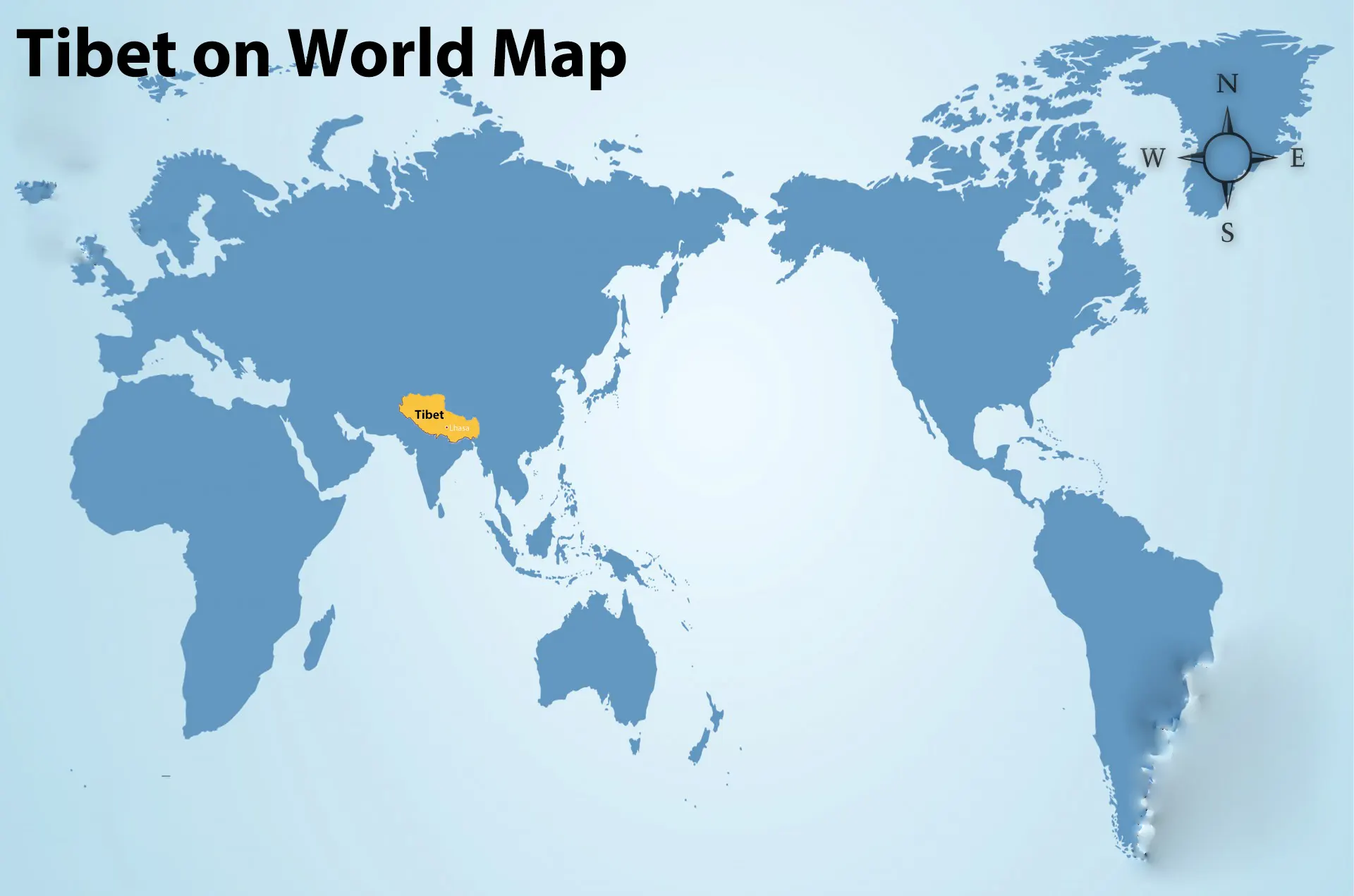 Tibet on World Map
Where is Tibet Located on the Asia Map?
On the Asia map, Tibet is located in the center of the Himalayan region in western China. It borders Nepal, India, Myanmar, and Bhutan to the south and is surrounded by several Chinese provinces and autonomous regions. Its strategic location makes Tibet an important gateway between East Asia and South Asia.
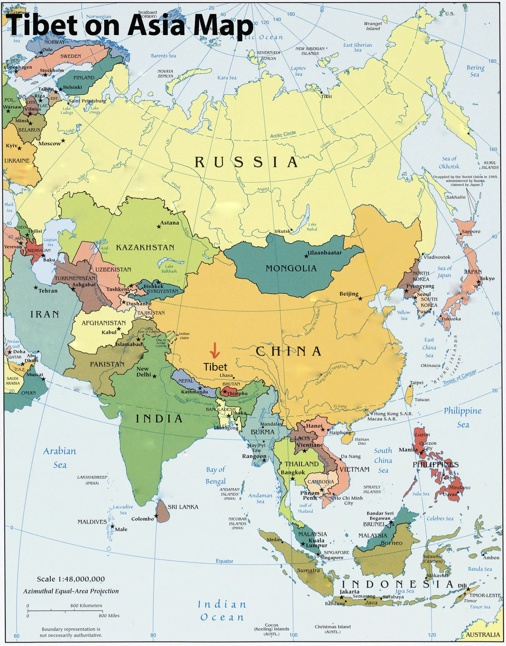 Tibet on Asia Map
Where is Tibet Located on the China Map?
On the Tibet China map, Tibet is located in the far southwest of the country. It borders the Chinese provinces of Qinghai, Sichuan, Yunnan, and Xinjiang, while its southern boundary follows the Himalayan mountain range. Covering about 1.2 million square kilometers, Tibet is one of China's largest provincial-level regions. It is famous for landmarks such as the Potala Palace, Mount Everest, Mount Kailash, and Namtso Lake.
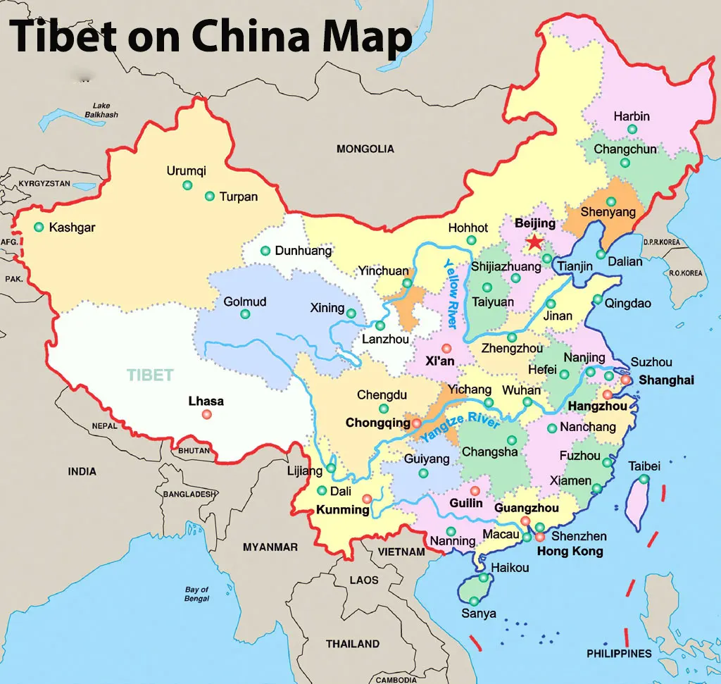 Tibet on China Map
How Do International Travelers Enter Tibet from the Chinese Mainland?
International travelers can enter Tibet from the Chinese Mainland by flight or train. Popular gateways include Beijing, Shanghai, Chengdu, Chongqing, Xi'an, Guangzhou, and Xining. If Tibet train tickets are sold out from your departure city, we recommend the "plane + train" option. For example, you can fly from Beijing to Xining, and then take the Qinghai-Tibet Railway from Xining to Lhasa.
Detailed Map of Tibet: Regional Position and Internal Geography
Tibet is one of the world's most remarkable high-altitude regions, known for its unique geography, rich culture, and spectacular natural landscapes. Before planning your Tibet trip, it is helpful to understand the region's key facts, including its location, population, climate, language, major cities, and natural resources. The following overview provides essential information about Tibet at a glance.
Capital City: Lhasa (3,600 m), population of about 870,000 (municipality)
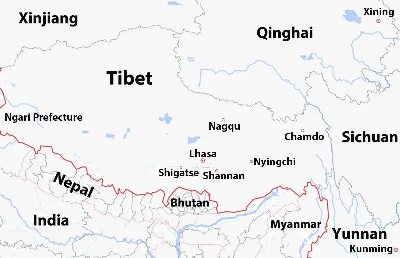
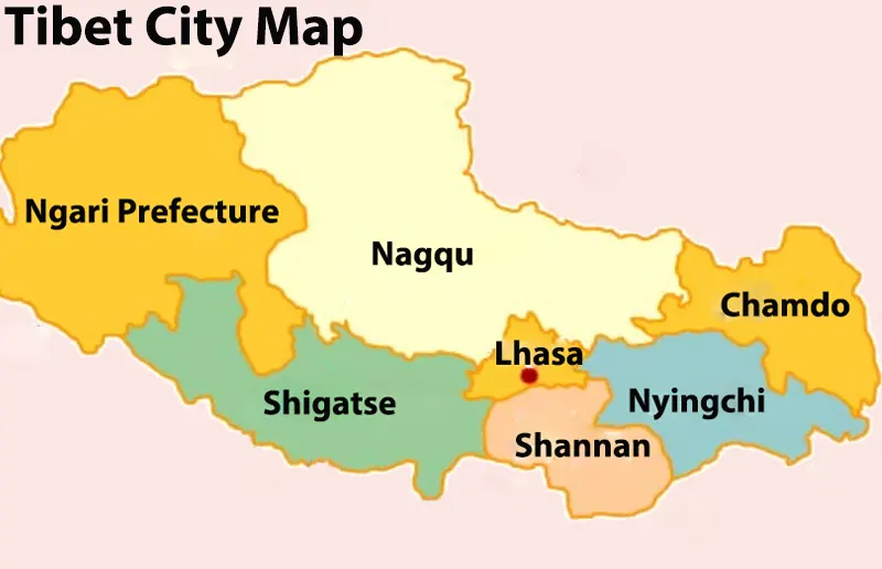
Administrative Divisions: 6 prefecture-level cities (Lhasa, Shigatse, Shannan, Nyingchi, Nagqu, Chamdo) and 1
prefecture (Ngari)
Total Area: About 1.23 million km², China's second-largest provincial-level region
Religion: Tibetan Buddhism (the dominant religion)
Average Altitude: Over 4,000 m
Highest Prefecture: Ngari (average elevation above 4,500 m)
Lowest Prefecture: Nyingchi (average elevation around 3,000 m)
UNESCO World Heritage Site: Potala Palace
Highest Lake: Namtso Lake (4,718 m)
Highest Point: Mount Everest (8,848.86 m)
Language: Tibetan and Mandarin Chinese
Bordering Countries: India, Nepal, Myanmar, and Bhutan
Economy: Agriculture, animal husbandry, tourism, and mining
Climate: Plateau climate with strong sunshine and large day-night temperature differences
Ethnic Groups: Tibetans, Han Chinese, Hui, Monpa, Lhoba, and other ethnic groups
Traditional Foods: Tsampa, yak meat, Tibetan momo, thukpa, butter tea
Wildlife: Wild yak, Tibetan antelope, snow leopard, black-necked crane, Tibetan gazelle, kiang (wild ass), wolf,
marmot, vulture
Mineral Resources: Chromite, copper, iron ore, lithium, borax, uranium, and gold.
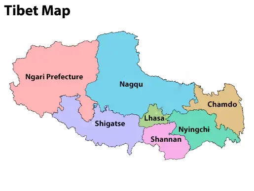 Tibet Map
The detailed map of Tibet shows the region's location, major cities, mountains, lakes, and transportation routes. Lhasa, the capital of Tibet, is the main gateway for most travelers. The map also highlights famous destinations such as Shigatse, Nyingchi, Mount Everest, Mount Kailash, Lake Mansarovar, Namtso Lake, and Yamdrok Lake. Understanding Tibet's internal geography helps you plan your itinerary, estimate travel distances, and choose the best route for your Tibet tour.
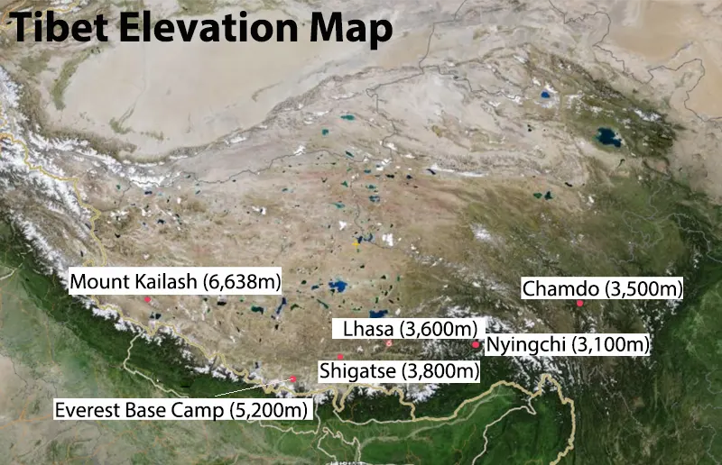
1) Tibet Elevation Map
A Tibet elevation map shows the region's dramatic altitude changes, from the lower valleys of Nyingchi to the high plains of central Tibet and the towering Himalayan peaks. It helps travelers understand elevation differences and plan a safe itinerary for altitude acclimatization.
 Tibet Elevation Map
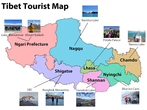
2) Tibet Tourist Map
A Tibet tourist map features the region's top attractions, including Lhasa, Potala Palace, Jokhang Temple, Yamdrok Lake, Mount Everest, Mount Kailash, and Lake Mansarovar. It helps you plan sightseeing routes and choose destinations based on your interests.
 Tibet Tourist Map
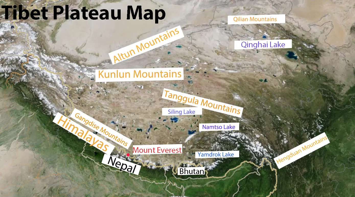
3) Tibet Plateau Map
A Tibet Plateau map highlights the vast Qinghai-Tibet Plateau, often called the "Roof of the World." It shows the plateau's major mountain ranges, rivers, lakes, and surrounding regions, providing a clear overview of Tibet's unique geography.
 Tibet Plateau Map
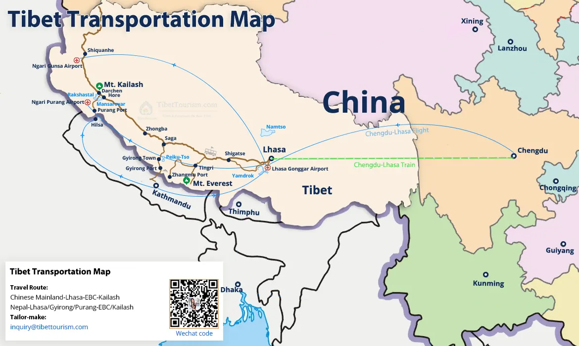
4) Tibet Transportation Map
A Tibet transportation map outlines the main travel routes by flight, train, and road. It includes major gateways, highways, and the Qinghai-Tibet Railway, making it easier to plan transportation across Tibet. The map below provides your reference for routes from the Chinese Mainland (taking Chengdu as an example) and Nepal to Lhasa.
 Tibet Transportation Map
Who Does Tibet Border? Neighboring Countries & Regions
Tibet shares international borders with four countries: Nepal, India, Bhutan, and Myanmar. Within China, it borders Xinjiang, Qinghai, Sichuan, and Yunnan. Tibet is located on the Tibetan Plateau and bordered by the Himalayas to the south. Its strategic location makes it an important gateway between China and South Asia. Several major overland travel routes connect Tibet with neighboring regions.
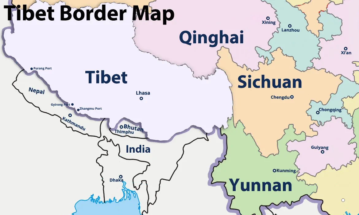 Tiber Border Map
Travel Tips Based on the Tibet Location Map
Tibet's unique geography features high mountains, vast plateaus, and significant elevation changes, so careful planning is essential. Allow time to acclimatize to the high altitude, pack layered clothing for changing weather, and choose a travel route that matches your itinerary. The Tibet map can help you understand distances, major attractions, and transportation routes before your Tibet tour.
FAQs about Tibet Location
1) What is the closest city to Tibet?
There is no single closest city to Tibet, as Tibet borders several Chinese provinces. The most popular gateway
cities are Chengdu, Xining, Chongqing, and Kunming, all of which offer regular flights or trains to Lhasa. Among
them, Xining is the starting point of the Qinghai-Tibet Railway journey to Lhasa.
2) Can I drive to Tibet from neighboring countries?
No. Foreign travelers cannot drive independently into Tibet from neighboring countries. The only international
overland tourist route is from Nepal via Gyirong or Zhangmu Border. You must join an organized tour arranged by
a licensed Tibet travel agency and obtain the required Tibet Travel Permit before entering Tibet.
3) Can I fly directly to Tibet?
Yes, you can fly directly to Tibet from several major cities in China, including Beijing, Shanghai, Chengdu, and
more. Flights can arrive at Lhasa Gonggar International Airport, Nyingchi Mainling Airport, Shigatse Peace
Airport, and Shigatse Tingri Airport. Before boarding your flight, you must obtain a Tibet Travel Permit through
a licensed Tibet travel agency, such as Tibet Horizon.
4) How does Tibet's geographical location affect its climate and ecology?
Tibet's high altitude creates a cold, dry plateau climate with strong sunshine, thin air, and large temperature
differences between day and night. The Himalayas block warm, moist monsoon winds from the Indian Ocean, making
Tibet one of the driest high-altitude regions in Asia. This unique geography supports alpine grasslands,
glaciers, and rare wildlife such as the Tibetan antelope and snow leopard. It also forms the headwaters of many
of Asia's major rivers, earning Tibet the nickname "Water Tower of Asia."
5) What makes Tibet’s location unique in Asia?
Tibet's location is unique because it lies on the Tibetan Plateau, the world's highest and largest plateau, with
an average elevation of over 4,000 meters. It is home to the Himalayas, including Mount Everest, and serves as
the source of many of Asia's major rivers, such as the Yangtze, Yellow, Mekong, Brahmaputra, and Indus. This
exceptional geography has earned Tibet the nickname "Water Tower of Asia."
6) What Tibet permits are legally required to cross into Tibet based on its border locations?
All foreign travelers must obtain a Tibet Travel Permit before entering Tibet, whether arriving by flight, train,
or road. Additional Tibet permits, like an Aliens' Travel Permit and a Military Area Entry Permit, are required for restricted areas such as Mount Kailash.
7) Which countries can you visit from Tibet?
From Tibet, international travelers can currently travel overland to Nepal through the Gyirong or Zhangmu Border.
Although Tibet borders India and Bhutan, these borders are not open to international tourists for regular
cross-border travel. Most international overland journeys from Tibet are therefore limited to Nepal.
Conclusion
Tibet location on the Tibetan Plateau makes it one of the world's most extraordinary destinations. Tibet is surrounded by towering mountains and borders several regions and countries. Its unique location creates spectacular landscapes, rich cultural heritage, and remarkable geographic significance. Use this Tibet location map to better understand the region and plan your Tibet tour.
10 years exp.| 5.0
 | Reviews
Tell me about your travel plan or contact me via inquiry@tibettourism.com
Related Tibet Travel Guide and Advice


Most Popular Tibet Tour Packages
-
![Lhasa Everest Base Camp Kathmandu Overland Small Group Tour]() Small Group Tour
Small Group Tour7 Days Lhasa Everest Base Camp Kathmandu Overland Small Group Tour
Promo: Classic overland travel route from Lhasa to Kathmandu via Gyirong / Nyalam
Dates & Price
![rili]()
![xiala]()
-
![Lhasa Shigatse Mount Everest Small Group Tour]() Small Group Tour
Small Group Tour8 Days Lhasa Shigatse Mount Everest Small Group Tour
Promo: Once-in-a-lifetime chance to face the tallest mountain in the world
Dates & Price
![rili]()
![xiala]()
-
![Kathmandu to Lhasa Overland Small Group Tour with EBC]() Small Group Tour
Small Group Tour8 Days Kathmandu to Lhasa Overland Small Group Tour with EBC
Promo: Drive Across Himalaya Overland Tour with altitude rising slowly
Dates & Price
![rili]()
![xiala]()


.webp)


Please share your contact information, so we can send you the answer directly by email.

