
 inquiry@tibettourism.com


.webp)


Tibet Political Map: Comprehensive Guide, Boundaries, and Administrative Regions


.webp) Content
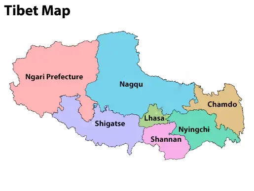
ContentTibet is historically and culturally distinct. Understanding a Tibet political map can help you better comprehend the region's administrative divisions and geographic boundaries. The Tibet Autonomous Region is divided into six prefecture-level cities and one prefecture, including Lhasa, Shigatse, Nyingchi, Chamdo, Nagqu, Shannan, and Ngari. A political map also shows major counties, district boundaries, and key transportation routes connecting different parts of Tibet. Whether you are planning a Tibet trip or exploring its geography, the Tibet political map makes it easier to understand how the region is organized.
Introduction to the Tibet Political Map
A Tibet political map is a useful reference for travelers, students, and anyone interested in Tibet's geography. Before exploring Tibet, it is helpful to understand how the region is organized and represented on modern political maps.
1) Overview of Tibet’s Geographical and Political Location
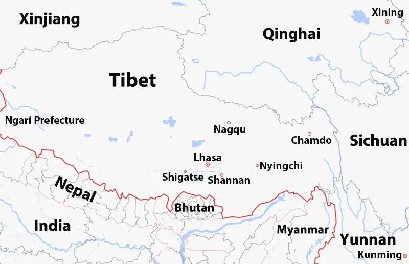
Situated on the lofty Qinghai-Tibet Plateau in East Asia, Tibet occupies a highly strategic geographical position. Politically, the Tibet Autonomous Region borders Qinghai Province to the northeast, Sichuan Province to the east, Yunnan Province to the southeast, and the Xinjiang Uygur Autonomous Region to the northwest. It also shares international borders with India, Nepal, Bhutan, and Myanmar to the south, southwest, and southeast.
2) Understanding the Tibet Autonomous Region (TAR) on World Maps
On modern world maps, Tibet is shown as the Tibet Autonomous Region (TAR) of China. The TAR covers approximately 1.23 million square kilometers in southwestern China and is one of the country's largest provincial-level regions. It is divided into six prefecture-level cities and one prefecture, with Lhasa serving as the regional capital and administrative center.
3) Key Features of a Modern Tibet Political Map
A modern Tibet political map highlights prefecture boundaries, major cities, counties, highways, railways, airports, and border crossings. It also shows important travel destinations, helping you understand Tibet's administrative layout and transportation network.
Administrative Capital: Clearly identifies Lhasa as the regional political, cultural, and economic center.
Internal Cities and Prefectures: Displays internal provincial subdivisions, including Shigatse, Nyingchi, Chamdo, Nagqu, Shannan (Lhoka), and Ngari.
International Borders: Outlines the high-altitude Himalayan borderlines separating the TAR from neighboring South Asian nations.
Major Transport Routes: Highlights key infrastructure networks, such as the Qinghai-Tibet Railway and major national highways connecting Lhasa to surrounding regions.
Key Elements Found on a Tibet Political Map
A Tibet political map highlights the region's administrative structure and transportation network. It helps travelers understand administrative boundaries, major cities, and key transport routes across the Tibet Autonomous Region (TAR). These features make it easier to plan trips and explore different parts of Tibet.
1) Administrative Borders & Capitals
The Tibet political map clearly marks the administrative borders of the Tibet Autonomous Region and its prefecture-level divisions. It also identifies major administrative centers, including Lhasa, the regional capital, as well as Shigatse, Nyingchi, Chamdo, Nagqu, Shannan, and Ngari. These boundaries help define each region's administrative jurisdiction.
2) Transport Networks & Border Passages
Beyond administrative lines, the Tibet political map highlights critical infrastructure that connects the plateau to the outside world. It includes the Qinghai-Tibet Railway, national highways, airports, and expressways. Important border crossings, such as the Gyirong or Zhangmu border, are also marked to help travelers understand cross-border access between Tibet and neighboring countries. These transport networks connect Tibet with major cities across China and South Asia.
Administrative Divisions of Tibet
The Tibet Autonomous Region (TAR) is divided into six prefecture-level cities and one prefecture. Each region has its own landscapes, cultural heritage, and popular attractions. Understanding these administrative divisions of Tibet helps you plan routes and explore different parts of the region.
| Region | Administrative Level | Avg. Altitude | Highlights |
|---|---|---|---|
| Lhasa | Prefecture-level City | 3650m | Potala Palace |
| Shigatse | Prefecture-level City | 3900m | Everest Base Camp |
| Nyingchi | Prefecture-level City | 3000m | Basum Tso |
| Chamdo | Prefecture-level City | 3900m | Ranwu Lake |
| Nagqu | Prefecture-level City | 4500m | Namtso |
| Shannan | Prefecture-level City | 3600m | Yamdrok Lake |
| Ngari | Prefecture | 4500m | Mount Kailash |
| Region | Administrative Level | Avg. Altitude | Highlights |
|---|---|---|---|
| Lhasa | Prefecture-level City | 3650m | Potala Palace |
| Shigatse | Prefecture-level City | 3900m | Everest Base Camp |
| Nyingchi | Prefecture-level City | 3000m | Basum Tso |
| Chamdo | Prefecture-level City | 3900m | Ranwu Lake |
| Nagqu | Prefecture-level City | 4500m | Namtso |
| Shannan | Prefecture-level City | 3600m | Yamdrok Lake |
| Ngari | Prefecture | 4500m | Mount Kailash |
1) The Six Prefecture-Level Cities and One Prefecture
Lhasa (Average Altitude of 3650m): the Regional Capital
Lhasa is the capital of the Tibet Autonomous Region and its political, economic, cultural, and religious center.
It covers an area of nearly 30,000 square kilometers, comprising 3 districts and 5 counties (with Chengguan
District serving as the main urban core). It is home to famous landmarks such as Potala Palace, Jokhang Temple,
and Norbulingka. Most travelers begin their Tibet journey in Lhasa.
Shigatse (Average Altitude of 3900m): Gateway to Mount Everest
Shigatse covers an area of over 180,000 square kilometers and administers 18 county-level divisions (1 district
and 17 counties). It is Tibet's second-largest city and the gateway to Everest Base Camp (EBC). It is also home
to the historic Tashilhunpo Monastery, the traditional seat of the Panchen Lama.
Nyingchi (Average Altitude of 3000m): The Eastern Himalayan Region
Nyingchi covers 116,175 square kilometers and has 7 county-level divisions: 1 district, 1 county-level city, and
5 counties. Located in southeastern Tibet, Nyingchi is known for its forests, rivers, and mild climate, earning
it a reputation as the "Switzerland of Tibet." Popular attractions include Basum Tso, Lulang Forest, and the
Yarlung Tsangpo Grand Canyon.
Chamdo (Average Altitude of 3900m): The Gateway to Eastern Tibet
Chamdo lies in eastern Tibet, where Tibet, Sichuan, and Qinghai meet. The region covers an area of 110,000 square
kilometers and includes 11 county-level divisions (1 district and 10 counties). It functions as a historical
crossroads along the Ancient Tea Horse Road and the commercial hub of eastern Tibet. It is an important
transportation hub and is famous for Jampaling Monastery and dramatic mountain valleys.
Nagqu (Average Altitude of 4500m): The Northern Plateau Area
Nagqu is located in northern Tibet and is one of the highest regions on the Qinghai-Tibet Plateau. The region
covers an area of 450,537 square kilometers and comprises 11 county-level divisions (1 district and 10
counties). It is known for vast grasslands, nomadic culture, and alpine lakes. Famous scenic spots include
Namtso Lake, the Qiangtang Grassland, and so on.
Shannan (Average Altitude of 3600m): The Cradle of Tibetan Culture
Located along the middle reaches of the Yarlung Tsangpo River in southern Tibet, Shannan is regarded as the
birthplace of Tibetan civilization. It comprises 12 county-level divisions (1 district, 1 county-level city, 10
counties). It is home to Yumbulakang Palace, Samye Monastery, and the Yarlung Valley, where Tibetan history
began.
Ngari Prefecture (Average Altitude of 4500m): The Western Border Frontier
Ngari Prefecture comprises 7 counties, covering an area of 304,000 square kilometers. As the only remaining
prefecture (non-city administrative division) in the TAR, Ngari is located at the westernmost point, bordering
India and Nepal. Renowned for holy sites like Mount Kailash and Lake Mansarovar, it represents one of the
world's most sparsely populated high-altitude regions.
 Tibet Political Map
2) Major Counties and Key Urban Centers
Below the prefecture level, the TAR is further subdivided into dozens of county-level administrative units and key urban centers. Notable centers include Gyantse County (famous for its historic fortress and stupa), Tingri County (the base for Mount Everest expeditions), and Purang County (a major border trade hub in Ngari). These local urban seats serve as vital regional administrative and commerce centers for surrounding rural and nomadic communities.
Borders and Neighboring Geopolitics
The Tibet political map shows both its international borders with South Asian countries and its domestic boundaries with neighboring Chinese provinces. Understanding these borders helps explain Tibet's geographic importance and major cross-border travel routes.
1) International Borders (India, Nepal, Bhutan, Myanmar)
To the south and west, Tibet forms China’s southern frontier along the formidable Himalayan range:
India: It shares the longest border section along the western and eastern sectors, marked by rugged terrain and key trade passes.
Nepal: Features major overland entry ports like Gyirong and Zhangmu, maintaining active diplomatic and trade connections with Lhasa.
Bhutan: Bordered by southern Tibet along a largely mountainous, remote frontier.
Myanmar: Meets the far southeastern corner of Tibet in a densely forested, high-mountain tri-junction area.
2) Domestic Provincial Borders (Xinjiang, Qinghai, Sichuan, Yunnan)
Internally, the Tibet Autonomous Region (TAR) is integrated into western China through four administrative provincial boundaries:
Xinjiang: Borders Tibet to the northwest across the desolate Kunlun Mountains and Aksai Chin area.
Qinghai: Adjoins northern Tibet and shares the vast, high-elevation Changtang Plateau. It is also connected to Tibet by the Qinghai–Tibet Railway and Qinghai–Tibet Highway, the region's two major transport corridors.
Sichuan: Connects to eastern Tibet (Kham region) along major river valleys and the Sichuan-Tibet Highway network.
Yunnan: Borders southeastern Tibet, linked historically by the Ancient Tea Horse Road trade routes.
Political Map vs Physical Map of Tibet
A Tibet political map shows administrative boundaries, prefecture-level cities, counties, and major transportation routes across the Tibet Autonomous Region. In contrast, a Tibet physical map highlights natural features such as mountains, rivers, lakes, and plateaus. A political map is ideal for understanding Tibet's administrative divisions and planning travel routes, while a physical map is better for exploring the region's geography and terrain.
FAQs about Tibet Political Map
Why a Tibet Political Map matters?
A political map of Tibet clearly shows administrative boundaries, prefectures, and counties across the Tibet
Autonomous Region. It helps travelers and researchers understand the region's administrative layout, plan
efficient travel routes, and locate the areas where different travel permits may be required.
What is the difference between Greater Tibet and the Tibet Autonomous Region?
The Tibet Autonomous Region (TAR) is an officially defined administrative region of China. Greater Tibet is a
cultural and historical term. It refers to the broader Tibetan cultural areas, including parts of Qinghai,
Sichuan, Gansu, and Yunnan, in addition to the Tibet Autonomous Region. The two terms describe different
geographic concepts and should not be used interchangeably.
Conclusion
A Tibet political map provides a clear overview of the Tibet Autonomous Region, including its administrative divisions, major cities, neighboring regions, and international borders. By understanding Tibet's political boundaries and regional layout, you can better explore its geography, history, and travel routes. Whether you are planning a Tibet tour or studying the region, the Tibet political map is an essential reference for understanding Tibet.
2 years exp.| 5.0
 | Reviews
Tell me about your travel plan or contact me via inquiry@tibettourism.com
Related Tibet Travel Guide and Advice


Most Popular Tibet Tour Packages
-
![Lhasa Everest Base Camp Kathmandu Overland Small Group Tour]() Small Group Tour
Small Group Tour7 Days Lhasa Everest Base Camp Kathmandu Overland Small Group Tour
Promo: Classic overland travel route from Lhasa to Kathmandu via Gyirong / Nyalam
Dates & Price
![rili]()
![xiala]()
-
![Lhasa Shigatse Mount Everest Small Group Tour]() Small Group Tour
Small Group Tour8 Days Lhasa Shigatse Mount Everest Small Group Tour
Promo: Once-in-a-lifetime chance to face the tallest mountain in the world
Dates & Price
![rili]()
![xiala]()
-
![Kathmandu to Lhasa Overland Small Group Tour with EBC]() Small Group Tour
Small Group Tour8 Days Kathmandu to Lhasa Overland Small Group Tour with EBC
Promo: Drive Across Himalaya Overland Tour with altitude rising slowly
Dates & Price
![rili]()
![xiala]()


.webp)


Please share your contact information, so we can send you the answer directly by email.

