
 inquiry@tibettourism.com


.webp)


Tibet City Maps: Major Cities, Tourist Attractions & Travel Routes


.webp) Content
ContentExploring Tibet starts with understanding what cities there are. Tibet city maps help you explore the region's major cities, top tourist attractions, and transportation routes. From Lhasa and Shigatse to Nyingchi, Shannan, Chamdo, Nagqu, and Ngari, each destination offers unique landscapes and cultural experiences. Use the guide to help you plan your Tibet tour with confidence.
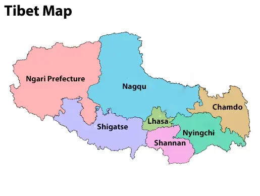
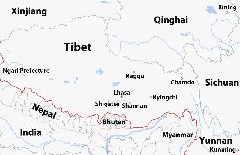
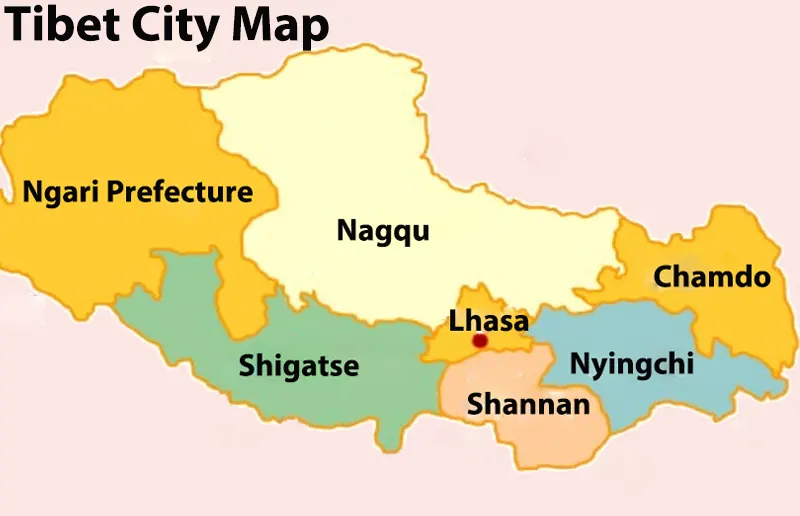 Tibet City Map
Tibet Cities Overview Table
Tibet's major cities each offer unique landscapes, cultural heritage, and travel experiences. Understanding their average elevation, best time to visit, and top attractions can help you choose the destinations that best match your interests. The table below provides a quick overview of each city's name, average elevation, best travel season, and key highlights.
| City | Average Elevation | Best Time to Visit | Key Highlights |
|---|---|---|---|
| Lhasa | 3,650m | Apr.–Jun., Sept.–Oct. |
Potala Palace, Jokhang Temple, Barkhor Street |
| Shigatse | 3,840m | Apr.–Jun., Sept.–Oct. |
Everest Base Camp, Tashilhunpo Monastery |
| Nyingchi | 3,100m | Mar.–May., Sept.–Oct. |
Namcha Barwa, Basum Tso, Peach Blossom Valley |
| Shannan (Lhoka) | 3,550m | Apr.–Jun., Sept.–Oct. |
Samye Monastery, Yumbulakang Palace, Yamdrok Lake |
| Chamdo | 3,240m | May.–Oct. | Jampaling Monastery, Ancient Tea Horse Road, River Canyons |
| Nagqu | 4,500m | Jun.–Sept. | Namtso Lake, Qiangtang Grassland, Nomadic Culture |
| Ngari Prefecture | 4,500m | May.–Oct. | Mount Kailash, Lake Mansarovar, Guge Kingdom Ruins |
| City | Average Elevation | Best Time to Visit | Key Highlights |
|---|---|---|---|
| Lhasa | 3,650m | Apr.–Jun., Sept.–Oct. |
Potala Palace, Jokhang Temple, Barkhor Street |
| Shigatse | 3,840m | Apr.–Jun., Sept.–Oct. |
Everest Base Camp, Tashilhunpo Monastery |
| Nyingchi | 3,100m | Mar.–May., Sept.–Oct. |
Namcha Barwa, Basum Tso, Peach Blossom Valley |
| Shannan (Lhoka) | 3,550m | Apr.–Jun., Sept.–Oct. |
Samye Monastery, Yumbulakang Palace, Yamdrok Lake |
| Chamdo | 3,240m | May.–Oct. | Jampaling Monastery, Ancient Tea Horse Road, River Canyons |
| Nagqu | 4,500m | Jun.–Sept. | Namtso Lake, Qiangtang Grassland, Nomadic Culture |
| Ngari Prefecture | 4,500m | May.–Oct. | Mount Kailash, Lake Mansarovar, Guge Kingdom Ruins |
Lhasa City Map: Top Attractions & Cultural Landmarks in Tibet’s Capital
Lhasa, the capital of Tibet, is the region's cultural and spiritual center. At an elevation of 3,650 meters, it serves as the starting point for almost every Tibet itinerary. Once you understand the city's layout, navigating Lhasa is easy, with its ancient sacred sites blending seamlessly with modern infrastructure.
Lhasa administers eight county-level divisions: Chengguan District, Doilungdêqên District, Dazi District, Lhünzhub County, Damxung County, Nyêmo County, Qüxü County, and Maizhokunggar County. Chengguan District is home to many of Lhasa's most famous attractions, including the Potala Palace, Jokhang Temple, Barkhor Street, Norbulingka, and Sera Monastery.
A Lhasa City map helps you locate these top attractions, plan efficient sightseeing routes, and explore the city's rich Tibetan heritage with ease.
Recommended Tours:
4-Day Lhasa Small Group Tour
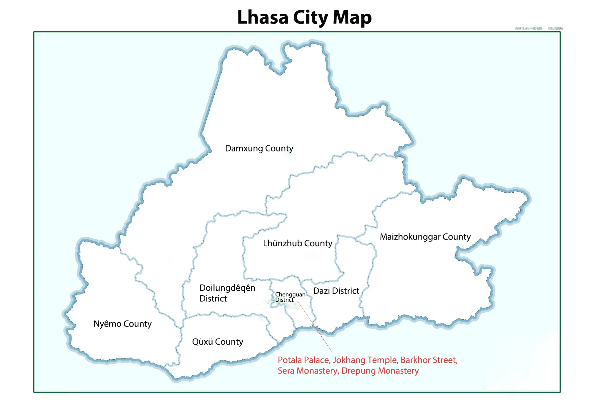 Lhasa City Map
Shigatse City Map: Gateway to Everest & Historic Monasteries
Shigatse, Tibet's second-largest city. It sits at an elevation of 3,800 meters and serves as the essential crossroads for travelers heading toward Mount Everest and Western Tibet.
Shigatse City is mainly composed of one municipal district (Samdrubtse District) and 17 counties, including Namling County, Gyantse County, Tingri County, Sakya County, Lhatse County, Ngamring County, and Xaitongmoin County. The city is also home to the famous Tashilhunpo Monastery, the traditional seat of the Panchen Lama. A Shigatse City map helps you locate major attractions, plan your route to Everest, and explore the city's rich history and Tibetan culture. Please see our comprehensive Shigatse City map below.
Recommended Tours:
8-Day Lhasa Shigatse Everest Base Camp Small Group Tour
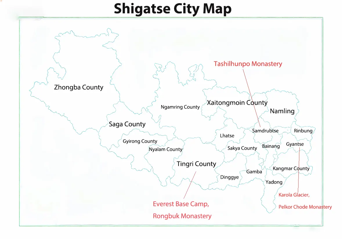 Shigatse City Map
Nyingchi City Map: Peach Blossom Valley & Lower-Altitude Scenic Spots
Nyingchi is known as the "Switzerland of Tibet." Its mild climate and average elevation of about 3,100 meters make it an ideal destination for travelers who want to acclimatize gradually. Nyingchi is mainly composed of Bayi District, Gongbo'gyamda County, Mainling City, Medog County, Bomi County, and Zayü County.
The region is famous for its Peach Blossom Valley, the spectacular Yarlung Tsangpo Grand Canyon, and the crystal-clear waters of Basum Tso Lake. Understanding Nyingchi's layout makes it easier to plan an efficient itinerary, explore its scenic valleys and lower-altitude highways, and continue west toward Lhasa. Use the detailed Nyingchi City map below to locate the region's top attractions and plan your journey with ease.
Recommended Tours:
9-Day Lhasa Nyingchi Bomi Yamdrok Lake Join-in Group Tour
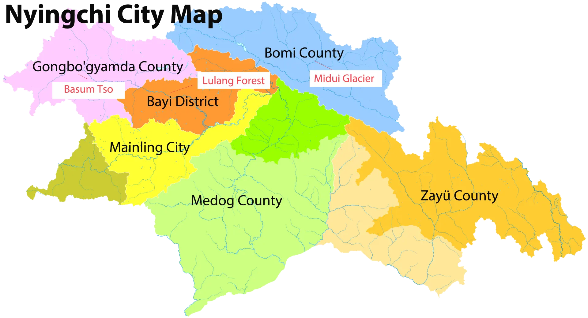 Nyingchi City Map
Chamdo City Map: Eastern Tibet’s Ancient Tea Horse Road & River Canyons
Chamdo is the gateway to eastern Tibet and an important stop on the historic Ancient Tea Horse Road. Changdu City is mainly composed of Karuo District, as well as Jomda County, Gonjo County, Lhorong County, Dengqen County, Chagyab County, Baxoi County, Zogang County, Markam County, Lhorong County, and Banbar County. The region is known for its deep river canyons, spectacular mountain scenery, and famous monasteries. Highlights like the historic Galden Jampaling Monastery and the dramatic gorges of the Mekong (Lancang) and Salween (Nu) rivers make Chamdo a compelling stop for overland adventure seekers. A Chamdo City map helps you locate major attractions, understand transportation routes, and explore this unique part of Tibet.
Recommended Tours:
13-Day Nyingchi Bomi Ranwu Chamdo Ngaqu and Lhasa Overland Tour
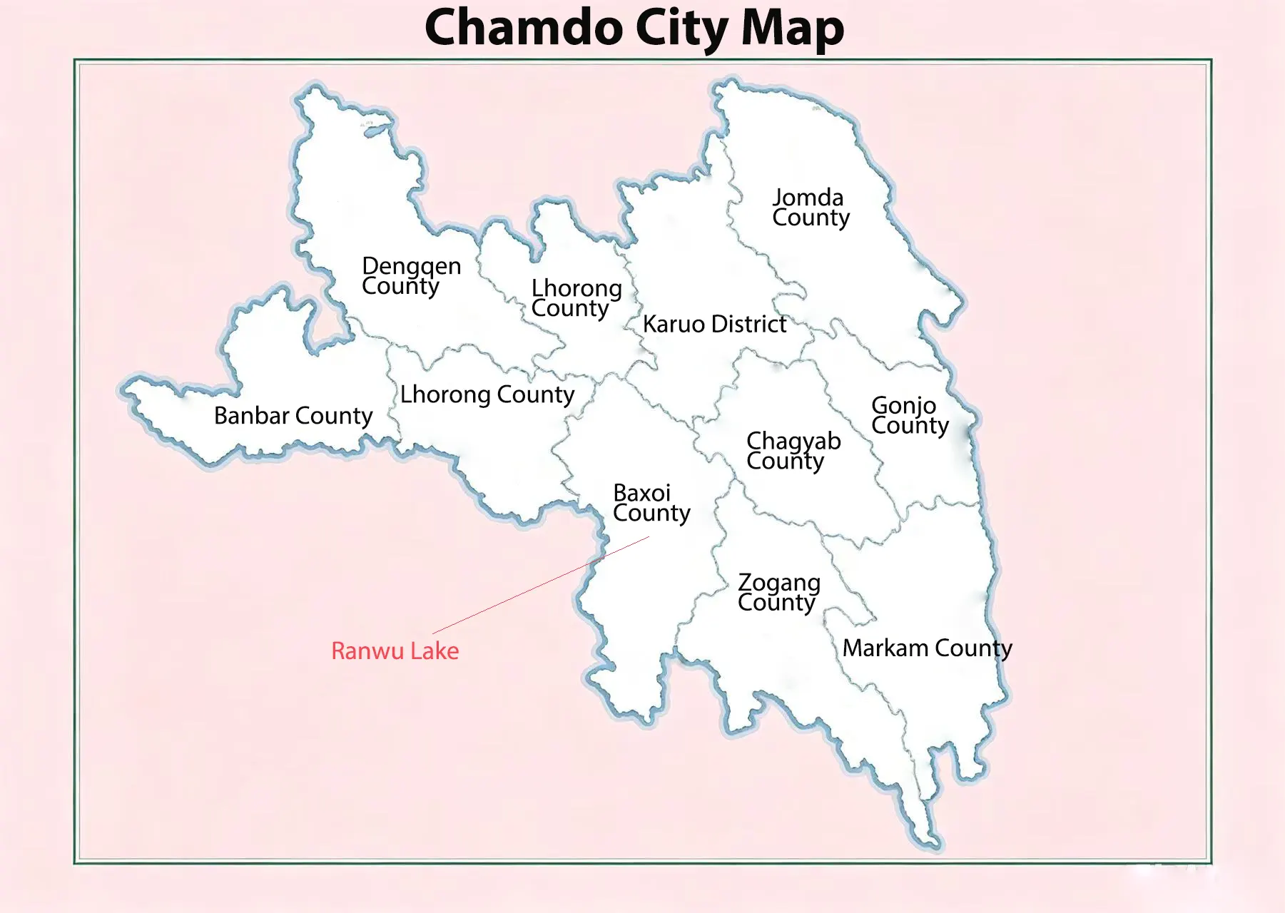 Chamdo City Map
Nagqu City Map: Sacred Lakes & the Vast Alpine Grasslands
Located in northern Tibet at an average elevation of over 4,500 meters, Nagqu is famous for its vast alpine grasslands, nomadic culture, and pristine high-altitude landscapes. Nagqu mainly consists of Seni District, Amdo County, Nyainrong County, Biru County, Jiali County, Suo County, Baqing County, Shenzha County, Baingoin County, Nyima County, and Shuanghu County.
It serves as the northern gateway along the Qinghai–Tibet Highway and Qinghai–Tibet Railway. The region is best known for Lake Namtso, the Qiangtang Grasslands, and the vast Qiangtang National Nature Reserve. Understanding Nagqu's layout helps you plan routes across its remote grasslands and high mountain passes while connecting central Tibet with northern Tibet. A Nagqu City map makes it easy to locate major attractions, transportation routes, and key travel hubs.
Recommended Tours:
9-Day Lhasa Shigatse Everest Base Camp Namtso Small Group Tour
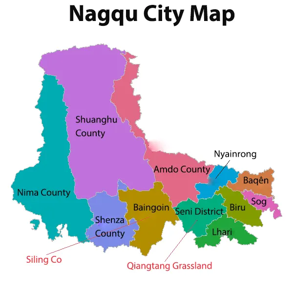 Nagqu City Map
Shannan City Map: Cradle of Tibetan Culture & Ancient Monasteries
Located south of the Yarlung Tsangpo River, Shannan (Lhoka) is widely celebrated as the cradle of Tibetan civilization. Shannan City is mainly composed of Nêdong District, Zhanang County, Gonggar County, Sangri County, Qonggyai County, Qusum County, Comai County, Lhozhag County, Gyaca County, Lhünzê County, Cona City, and Nagarzê County. This culturally rich region is home to Tibet's first palace, Yumbulagang, its first Buddhist monastery, Samye Monastery, and the scenic alpine waters of Yamdrok Lake. Navigating Shannan’s ancient valleys and sacred heritage sites offers you a deep dive into the roots of Tibetan history. A Shannan City map helps you locate these top attractions, plan sightseeing routes, and explore the rich history and culture of southern Tibet.
Recommended Tours:
6-Day Lhasa Yamdrok Shigatse Central Tibet Culture Small Group Tour
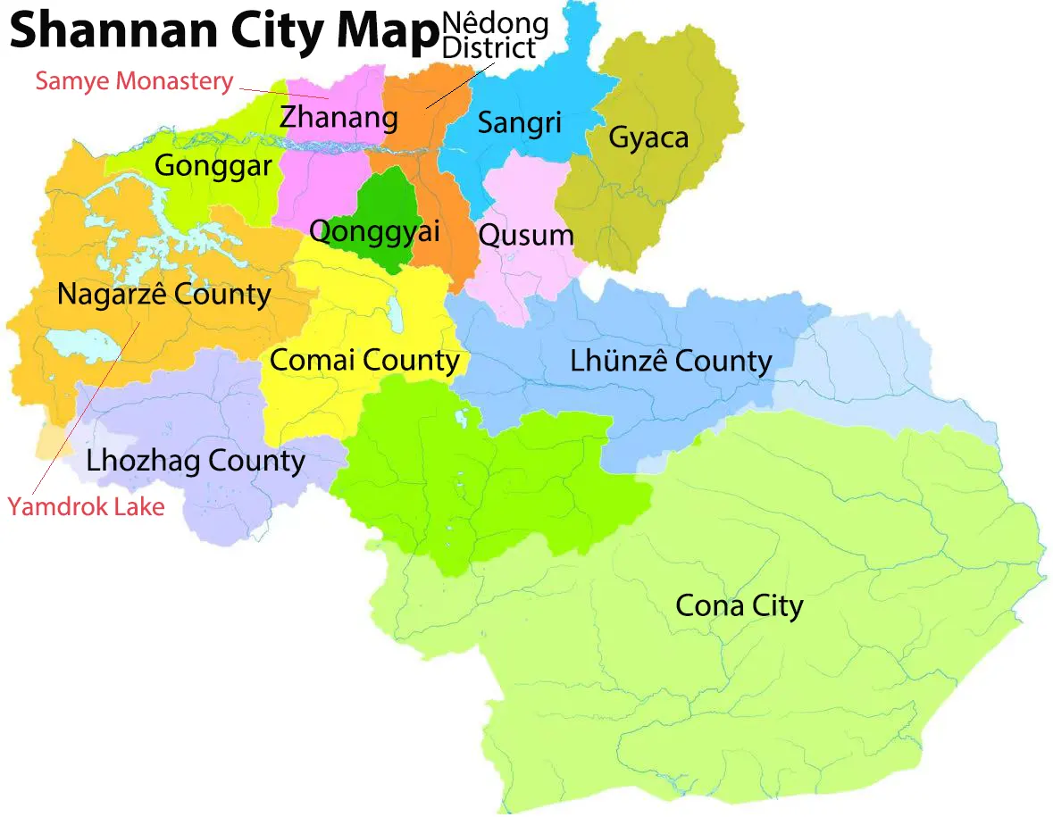 Shannan City Map
Ngari Prefecture Map: Mount Kailash Pilgrimage Routes & Western Frontiers
Ngari Prefecture is located in western Tibet and is best known for Mount Kailash and Lake Mansarovar, two of Asia's most sacred pilgrimage sites. The region also features vast plateau landscapes, ancient ruins, and remote border areas. An Ngari Prefecture map helps you locate major attractions, follow the Mount Kailash Kora route, and plan your journey across western Tibet.
Recommended Tours:
12-Day Lhasa Everest Kailash Mansarovar Gyirong/Zhangmu Kathmandu Small Group Tour
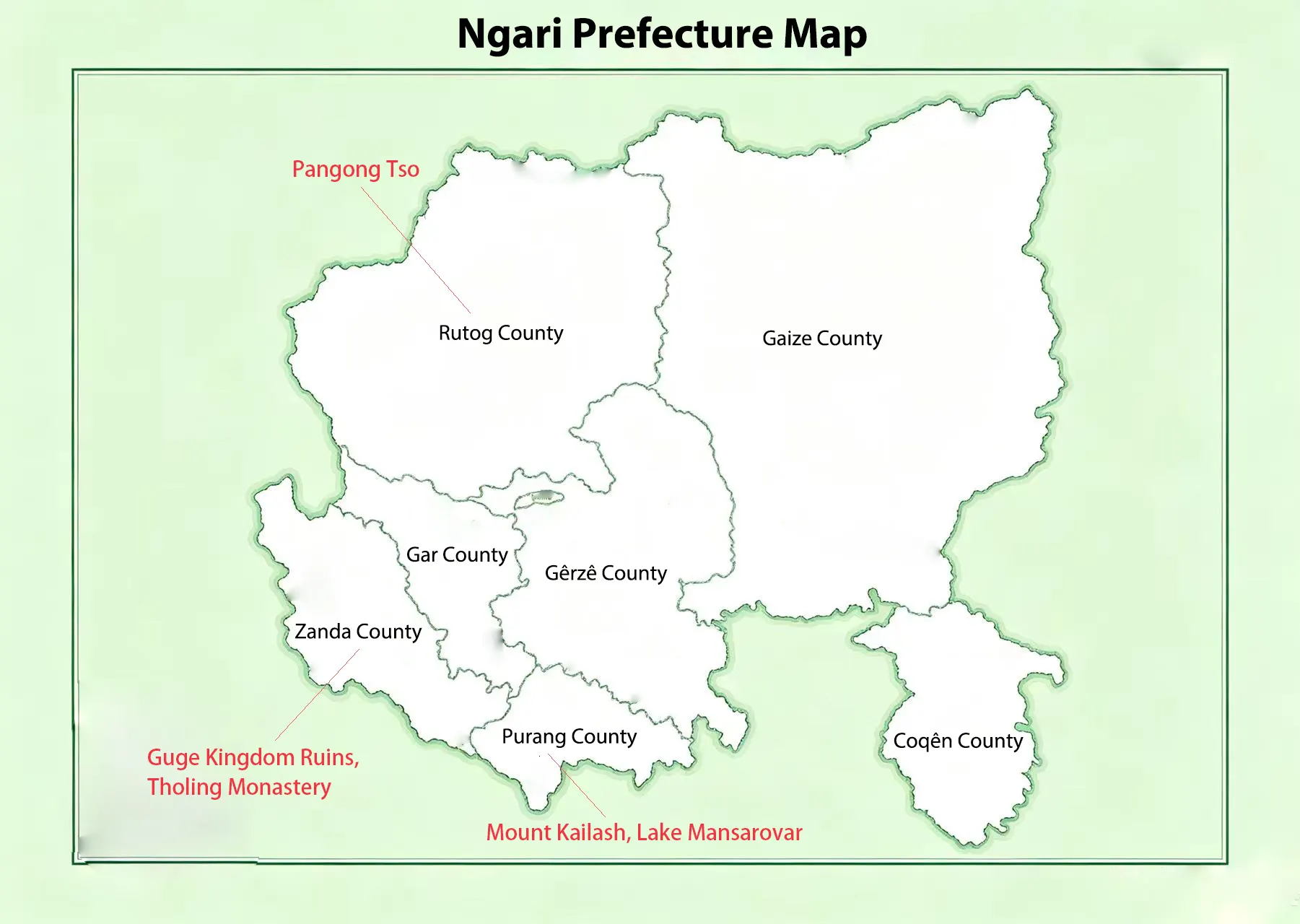 Ngari Prefecture Map
Top Tibet Travel Routes & Road Trip Maps
Tibet offers some of the world's most scenic overland journeys, connecting Lhasa with Shigatse, Nyingchi, Nagqu, Chamdo, Shannan, and Ngari. These routes pass through high mountain passes, sacred lakes, and historic monasteries. A Tibet travel route map helps you plan your itinerary, estimate travel distances, and choose the best road trip across Tibet.
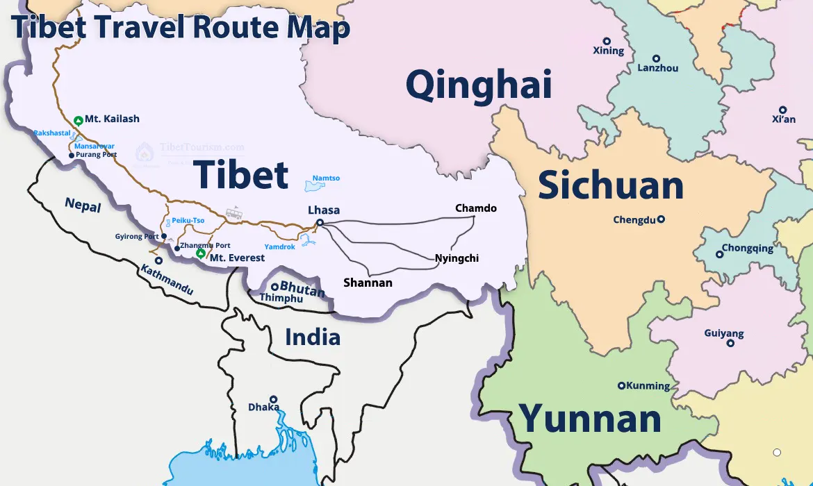 Tibet Travel Route Map
Essential Tips for Using Maps & Traveling in Tibet
Due to regional regulations, foreign tourists cannot travel independently in Tibet and must be accompanied by a licensed guide. Using detailed Tibet city maps helps you better understand daily travel distances, altitude changes, and city layouts before setting off on regional overland routes.
FAQs about Tibet City Maps
1) What is the most famous city in Tibet?
Lhasa is the most famous city in Tibet and the capital of the Tibet Autonomous Region. It is home to world-famous
landmarks such as the Potala Palace, Jokhang Temple, and Barkhor Street. Most Tibet tours begin in Lhasa before
continuing to destinations like Shigatse and Everest Base Camp.
2) Which city is best for first-time visitors?
Lhasa is the best city for first-time visitors to Tibet. As the capital of Tibet, it is home to iconic
attractions such as the Potala Palace, Jokhang Temple, and Barkhor Street. Most Tibet tours begin in Lhasa,
making it the ideal starting point for exploring the region.
3) Can I fly to every city in Tibet?
No. Lhasa, Nyingchi, Shigatse, Shannan, Chamdo, and Ngari have airports with scheduled flights. However, Nagqu
currently does not have a commercial passenger airport, so It’s usually reached by road or train from Lhasa or
other nearby cities.
4) Which Tibet city has the best weather?
Nyingchi has the mildest climate in Tibet. Located in southeastern Tibet, it enjoys lower altitude, warmer
temperatures, and more rainfall than other regions. Spring and autumn are especially popular for sightseeing,
with peach blossoms in spring and colorful forests in autumn.
5) Which Tibet city is best for altitude acclimatization?
Nyingchi is the best city for altitude acclimatization. With an average elevation of about 3,100 meters, it is
lower than Lhasa, Shigatse, and Nagqu. Many travelers choose to start their Tibet journey in Nyingchi before
continuing to higher-altitude destinations such as Lhasa and Everest Base Camp.
6) How many days do I need for a Lhasa and Everest route?
A Lhasa to Everest Base Camp tour usually takes 7–8 days. This itinerary includes sightseeing in Lhasa, visits to Gyantse and Shigatse, and an overland journey to Everest Base Camp (North). The schedule also allows time for
altitude acclimatization. If you need anything, please contact us.
7) Can I travel independently in Tibet with a Google Map?
No. Foreign travelers cannot travel independently in Tibet, even if they use Google Maps or other navigation
apps. You must join an organized Tibet tour arranged by a licensed Tibet travel agency, like Tibet Horizon. The
agency will help you to obtain a Tibet Travel Permit before entering Tibet.
8) What is the best time of year to travel these routes?
The best time to travel Tibet's popular routes is pring (April–June) and autumn (September–October). These seasons offer pleasant weather, clear skies, and excellent views of the Himalayas and Mount Everest. They are
also the most popular months for sightseeing and road trips across Tibet.
Conclusion
Tibet city maps make it easy to explore Lhasa, Shigatse, Nyingchi, Shannan, Chamdo, Nagqu, and Ngari. From famous landmarks and sacred monasteries to scenic road trips and Everest Base Camp, each destination offers a unique travel experience. Use these Tibet city maps to plan your itinerary, discover top attractions, and enjoy a smooth Tibet tour.
10 years exp.| 5.0
 | Reviews
Tell me about your travel plan or contact me via inquiry@tibettourism.com
Related Tibet Travel Guide and Advice


Most Popular Tibet Tour Packages
-
![Lhasa Everest Base Camp Kathmandu Overland Small Group Tour]() Small Group Tour
Small Group Tour7 Days Lhasa Everest Base Camp Kathmandu Overland Small Group Tour
Promo: Classic overland travel route from Lhasa to Kathmandu via Gyirong / Nyalam
Dates & Price
![rili]()
![xiala]()
-
![Lhasa Shigatse Mount Everest Small Group Tour]() Small Group Tour
Small Group Tour8 Days Lhasa Shigatse Mount Everest Small Group Tour
Promo: Once-in-a-lifetime chance to face the tallest mountain in the world
Dates & Price
![rili]()
![xiala]()
-
![Kathmandu to Lhasa Overland Small Group Tour with EBC]() Small Group Tour
Small Group Tour8 Days Kathmandu to Lhasa Overland Small Group Tour with EBC
Promo: Drive Across Himalaya Overland Tour with altitude rising slowly
Dates & Price
![rili]()
![xiala]()


.webp)


Please share your contact information, so we can send you the answer directly by email.

