
 inquiry@tibettourism.com






Tibet Tourist Maps
Tibet has so many tourist attractions to offer to people who wish to be surprised by this land. If you are planning your Tibet tour right now, you can have a look at some tourist maps of Tibet and figure out where you want to go. Below are some Tibet travel maps provided for you to have a check on those main scenic spots in Lhasa, Shigatse, Nyingchi, Nagri, Nagqu, Shannan, and Chamdo. You can always find some places that you are eager to go on those travel maps if you want to enjoy your time in Tibet.
Tourist Map of Tibet Autonomous Region
Usually, Tibet has seven tourists areas according to its administrative division and also the opinion of thousands of tourists who have been here before, including Lhasa, Shigatse, Nyingchi, Nagqu, Shannan, and Chamdo. Among those areas, Lhasa is the main tourist destination for visitors to stay. And many tourists come to Tibet because they have heard the main attractions in Tibet from others' travel stories, which are Potala Palace, Jokhang Temple, Everest Base Camp, Ganden Monastery, Namtso Lake, Yamdrok Lake, Mount Kailash, Tashilhunpo Monastery, etc. Check the map below to know where they are in Tibet.
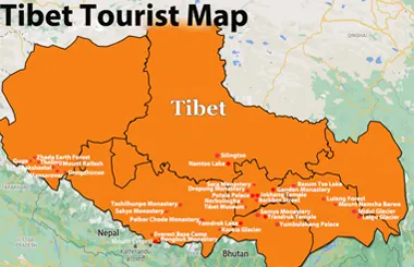
Tibet Tourist Map
A Tibet tourist map shows the locations of major attractions, cities, monasteries, lakes, and mountain destinations across Tibet. It serves as a practical guide for you to plan your itinerary and navigate high-altitude attractions efficiently.
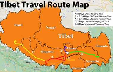
Tibet Travel Route Map
For tourists who want to pay a visit to most of those attractions in Tibet, you can follow this classic travel route from Lhasa to Mount Everest via Shigatse. This eight-day classic Tibet travel route will take you to enjoy the most beautiful scenery that Tibet can offer, including Yamdrok Lake, Korala Glacier, Pelkhor Chode Monastery, Tashilhunpo Monastery, Sakya Monastery, Rongbuk Monastery, Everest Base Camp, Mount Kailash, Mansarovar Lake, etc.
Tourist Maps of Tibet City and Prefecture
Lhasa Tourist Map
Lhasa is the capital of the Tibet Autonomous Region. And it is also the first stop for most tourists coming to Tibet. So, Lhasa can make every tourist feel amazed with its glorious scenery and grand culture relics. Spend two days in Lhasa and you will be able to pay a visit to those must-see attractions in this city, which include the Potala Palace, Jokhang Temple, Barkhor Street, Norbulingka, Sera Monastery, and Drepung Monastery.
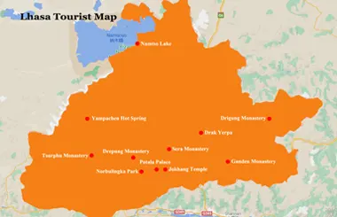
Lhasa Tourist Map
The Lhasa tourist map highlights major attractions, sacred temples, and historic quarters. It helps you locate landmarks such as the Potala Palace, Jokhang Temple, and Barkhor Street and plan your sightseeing routes more easily.
- Lhasa Chengguan District: Downtown Map & Top Attractions
- Lhasa City Map: Top Attractions, Districts & Travel Routes
- Lhasa Travel Map: Attractions, Hotels, Food, Nightlife & Routes
Shigatse Tourist Map
From Lhasa to Shigatse, tourists can take a train or have an overland tour. The train will take less than 3 hours and a ride will take about 5 hours. Along the Yarlung Tsangpo River, tourists will get the chance to enjoy the scenery along the road. The splendid Yamdrok Lake will be a surprise for everyone. Shigatse offers so many attractions, including Tashilhunpo Monastery, Pelkhor Chode Monastery, Sakya Monastery, Mount Everest, Everest Base Camp, Rongbuk Monastery, Rongbuk Glacier, etc.
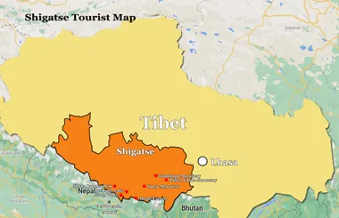
Shigatse Tourist Map
The Shigatse tourist map outlines scenic highlights across the region, including Mount Everest and historic monasteries. It provides clear navigational guidance to help you plan you Shigatse journey.
Ngari Tourist Map
Mount Kailash and Lake Mansarovar are the main tourists attractions in Ngari Prefecture. And most tourists will come to pay a visit to those two sacred destinations no matter how tough it will be on the road. The average altitude of Ngari is over 4,500 meters above sea level, which makes it known as "the Roof of the Roof of the World," "the Third Pole of the World," and "the Forbidden Zone of Life." However, this area still attracts those adventurous people who admire wildlife and ancient civilization of Tibet. Except for Mount Kailash and Lake Mansarovar, Ngari Prefecture also has Guge Kingdom, Zhada Earth Forest, Tholing Monastery, Pangong Tso Lake to offer to those who are brave enough to step into this land.
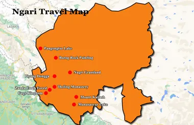
Ngari Tourist Map
The Ngari tourist map highlights major attractions and sacred sites in western Tibet. It helps you plan routes to destinations such as Mount Kailash, Lake Mansarovar, and Guge Kingdom Ruins.
Nyingchi Tourist Map
Well known as "the Switzerland of Tibet," Nyingchi boasts many natural marvels for tourists to enjoy. Located at an average elevation of 3,100 meters above sea level, Nyingchi can be a great place for tourists to travel in Tibet while feeling comfortable all the time. Here tourists will have a look at some beautiful scenery, like Mount Namjagbarwa, Niyang River, Basumtso Lake, Lulang Forest, Midui Glacier, etc. It only has a 4.5-hour ride from Lhasa, and most tourists will choose to have a tour to this beautiful place.
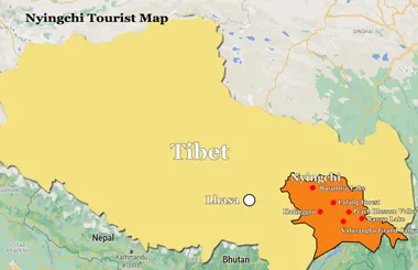
Nyingchi Tourist Map
The Nyingchi tourist map clearly marks top scenic highlights, such as Namcha Barwa, Basum Lake, and Lulang Forest. It serves as an essential travel guide to help you navigate key attractions in eastern Tibet.
Shannan Tourist Map
As a national-level scenic spot in Tibet, Shannan can also be a great destination in a lifetime Tibet tour. Lhasa Gonggar Airport is located in the region, making it a convenient gateway for travelers exploring southern Tibet. Many tourists come to Shannan for Samye Monastery, Trandruk Monastery, Yumbulagang Palace, Yamdrok Lake, Yarlung Tsangpo Valley, Dorje Drak Monastery, etc.
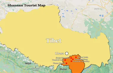
Shannan Tourist Map
The Shannan tourist map guides you through the region's top cultural landmarks and scenic landscapes. It provides clear details to help you easily explore major historical sites and natural attractions.
Nagqu Tourist Map
Located in the northern part of Tibet and the hinterland of the Qinghai-Tibet Plateau, Nagqu is the source of the Yangtze River, Nujiang River, Lhasa River, and other great rivers. Every year, the grand Nagqu Horse Racing Festival will be held here. If you intend to visit this place, you can take a train and get off at Nagqu Railway Station. It will show you great sites, which include Qiangtang Prairie, Nyenchen Tangula Mountain, Silingtso Lake, Tangra Yum Tso, etc.
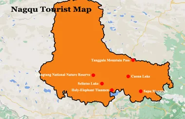
Nagqu Tourist Map
The Nagqu tourist map highlights major attractions, scenic grasslands, and lakes across Nagqu in northern Tibet. It helps you locate destinations such as Namtso Lake and Changtang grassland and plan routes through this vast region.
Chamdo Tourist Map
Chamdo is the birthplace of Kangba Culture. Bordering with Sichuan, Yunnan, and Qinghai makes this place a little different from other places in Tibet in Language, clothing, religion, folk custom, folk culture, and other aspects. Well-known destinations in Chamdo include Galden Jampaling Monastery, Ranwu Lake, Karuo Cultural Site, etc.
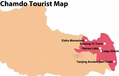
Chamdo Tourist Map
The Chamdo tourist map highlights major attractions, monasteries, and natural landscapes across Chamdo in eastern Tibet. It serves as an essential guide for you to navigate the diverse high-altitude landscapes and cultural sites.
No documents found.
No documents found.
No documents found.
Most Classic Tibet Tour Packages
Join our Tibet tour packages to explore the most iconic destinations. Visit Lhasa’s famous landmarks, admire the sacred Yamdrok Lake, discover Tibetan culture in Shigatse, and enjoy breathtaking views of Mount Everest. Whether you prefer a short cultural trip or an extended overland adventure, Tibet Horizon offers well-planned itineraries to help you experience the best of Tibet.
-
![Holy Lhasa City Small Group Tour]() Small Group Tour
4 Days Holy Lhasa City Small Group Tour
Promo: Explore the Architecture & Landscape of Lhasa
Dates & Price
![rili]()
![xiala]()
-
![Lhasa Shigatse Mount Everest Small Group Tour]() Small Group Tour
8 Days Lhasa Shigatse Mount Everest Small Group Tour
Promo: Once-in-a-lifetime chance to face the tallest mountain in the world
Dates & Price
![rili]()
![xiala]()
-
![Lhasa to Everest Kailash and Mansarovar Small Group Tour]() Small Group Tour
15 Days Tibet Mount Kailash and Lake Mansarovar Small Group Tour
Promo: Western Tibet tour around Mount Kailash
Dates & Price
![rili]()
![xiala]()
-
![Lhasa Yamdrok Shigatse Central Tibet Culture Small Group Tour]() Small Group Tour
6 Days Lhasa Yamdrok Shigatse Central Tibet Culture Small Group Tour
Promo: Taste the essence of Tibetan Culture in central Tibet
Dates & Price
![rili]()
![xiala]()
-
![Lhasa Shigatse Everest Base Camp Namtso Small Group Tour]() Small Group Tour
9 Days Lhasa Shigatse Everest Base Camp Namtso Small Group Tour
Promo: Unveil the profound spirituality and natural beauty that lie within the heart of Tibet.
Dates & Price
![rili]()
![xiala]()
-
![Lhasa Everest Kailash Mansarovar Guge Kingdom Full Moon Small Group Tour]() Small Group Tour
17 Days Lhasa Everest Kailash Mansarovar Guge Kingdom Full Moon Small Group Tour
Promo: Explore western Tibetan spirituality and culture around the sacred Mount Kailash
Dates & Price
![rili]()
![xiala]()
-
![Lhasa Yamdrok Lake Small Group Tour]() Small Group Tour
5 Days Lhasa Yamdrok Lake Small Group Tour
Promo: Marvel at the Heavenly Lake - Yamdrok Lake
Dates & Price
![rili]()
![xiala]()
-
![Lhasa Namtso Lake Small Group Tour]() Small Group Tour
5 Days Lhasa Namtso Lake Small Group Tour
Promo: Expose the age-old spiritual wisdom and magnificent natural wonders that are concealed in the heartland of Tibet.
Dates & Price
![rili]()
![xiala]()
-
![Lhasa Ganden Monastery Drak Yerpa Small Group Tour]() Small Group Tour
5 Days Lhasa Ganden Monastery Drak Yerpa Small Group Tour
Promo: Reveal the deep-seated religious essence and stunning landscapes that exist within the core of Tibet
Dates & Price
![rili]()
![xiala]()
-
![Old Tingri to Everest Base Camp Trek Small Group Tour]() Small Group Tour
10 Days Old Tingri to Everest Base Camp Trek Small Group Tour
Promo: Embark on the ultimate trekking adventure to Mount Everest Base Camp.
Dates & Price
![rili]()
![xiala]()
-
![Tibet Nepal Bhutan Small Group Tour]() Small Group Tour
13 Days Tibet Nepal Bhutan Small Group Tour
Promo: Unveil the spiritual and natural mysteries concealed in the Himalayan Mountains.
Dates & Price
![rili]()
![xiala]()
-
![Kathmandu to Lhasa Overland Small Group Tour with EBC]() Small Group Tour
8 Days Kathmandu to Lhasa Overland Small Group Tour with EBC
Promo: Drive Across Himalaya Overland Tour with altitude rising slowly
Dates & Price
![rili]()
![xiala]()
-
![Lhasa Everest Base Camp Kathmandu Overland Small Group Tour]() Small Group Tour
7 Days Lhasa Everest Base Camp Kathmandu Overland Small Group Tour
Promo: Classic overland travel route from Lhasa to Kathmandu via Gyirong / Nyalam
Dates & Price
![rili]()
![xiala]()
-
![Lhasa Everest Kailash Mansarovar Gyirong/Zhangmu Kathmandu Small Group Tour]() Small Group Tour
12 Days Lhasa Everest Kailash Mansarovar Gyirong/Zhangmu Kathmandu Small Group Tour
Promo: Uncover the spiritual and natural secrets hidden within Tibet
Dates & Price
![rili]()
![xiala]()
-
![Lhasa Everest Kailash Mansarovar Lhasa Tour with Inner Travel Gateway]() Small Group Tour
16 Days Lhasa Everest Kailash Mansarovar Lhasa Tour with Inner Travel Gateway
Promo: Complete 3-Day Kailash Kora and 1-Day Inner Kora Gateway Excursion
Dates & Price
![rili]()
![xiala]()








FAQs on Tibet Tourist Maps
Tibet’s top attractions include Potala Palace, Jokhang Temple, Yamdrok Lake, Mount Everest, Mount Kailash, Lake Mansarovar, and Namtso Lake. These sites showcase Tibet’s rich Buddhist heritage, sacred landscapes, and dramatic mountain scenery.
2) Where are the main tourist attractions in Tibet located?Tibet’s main attractions are spread across several regions. Lhasa is known for Potala Palace and Jokhang Temple, while Shigatse offers access to Mount Everest. Shannan features Samye Monastery and Yumbulagang Palace; Nyingchi is famous for forests and valleys; and Ngari is home to Mount Kailash and Lake Mansarovar.
3) How far apart are Tibet’s major tourist attractions?Distances between Tibet’s major attractions vary widely. Potala Palace and Jokhang Temple are both in central Lhasa, while Lhasa to Yamdrok Lake takes around 2–3 hours by road. Reaching Everest Base Camp usually takes one to two days from Lhasa, depending on the route and stops. A Tibet tourist map helps you estimate distances and plan travel times.
4) Which attractions are along the road from Lhasa to Mount Everest?The Lhasa to EBC overland route typically passes through Yamdrok Lake, Karola Glacier, Pelkhor Chode Monastery, Gyatso La Pass, and Gawu La Pass. These stops offer a mix of Tibetan culture, historic sites, and Himalayan scenery.
5) What are the main tourist routes connecting Tibet’s top attractions?Popular Tibet travel routes include the Lhasa–Shigatse–EBC route, the Lhasa–Namtso Lake route, and the Nyingchi-Lhasa route. Travelers seeking a longer adventure can follow the Lhasa–Everest–Mount Kailash route. The best itinerary depends on your available time, interests, and travel requirements.
6) How can I find Tibet’s major attractions on a tourist map?Use a Tibet tourist map to locate major cities, monasteries, lakes, mountain passes, and scenic areas. Start by identifying Lhasa, then trace the roads connecting it to destinations such as Shigatse, Everest Base Camp, Namtso Lake, and Mount Kailash. Check road routes and distances before traveling, especially when visiting remote areas where mobile signals may be limited.
