
 inquiry@tibettourism.com








Tibetan Plateau Facts: Location, Altitude, Climate & Geography


 Content
The Tibetan Plateau averages over 4,000 meters above sea level and features towering mountains, vast grasslands, glaciers, and ancient lakes. What is the Tibetan Plateau known for? Often called the "Roof of the World" and the "Third Pole," it is home to some of Asia's highest peaks and the sources of its major rivers. From its geological history and unique wildlife to its diverse cultures and high-altitude railways, the plateau offers many fascinating features. Discover 20 interesting facts about this remarkable region and what makes it one of the most extraordinary places on Earth.
Quick Facts About the Tibetan Plateau:
Nickname: The Roof of the World and the Third Pole.
Location: East and Central Asia, mainly in western China.
Area: Approximately 2.5 million square kilometers.
Average Elevation: Over 4,000 meters above sea level.
Highest Peak: Mount Everest (8,848.86 meters).
Formation: Uplifted by the collision of the Indian and Eurasian tectonic plates.
Ecosystem: Tibetan antelopes, wild yaks, Tibetan wild asses, snow leopards, and black-necked cranes.
 Tibetan Plateau
Location, Elevation & Geography
The Tibetan Plateau is a geographical marvel whose sheer scale and elevation shape the natural landscape of Asia. Spanning millions of square kilometers across East Asia, this ancient landform holds some of the most remarkable physical features on Earth.
Fact 1: The Tibetan Plateau Is Known as the Roof of the World
The Tibetan Plateau is widely known as the "Roof of the World" because of its exceptionally high elevation. Its vast, elevated landscape makes it one of the most distinctive regions on Earth.
Fact 2: It Is the World's Largest and Highest Plateau
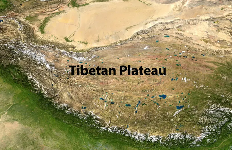
Covering around 2.5 million square kilometers, the Tibetan Plateau is the world's largest and highest plateau. It extends across the Tibet Autonomous Region, Qinghai, and parts of Sichuan, Yunnan, and Xinjiang in China.
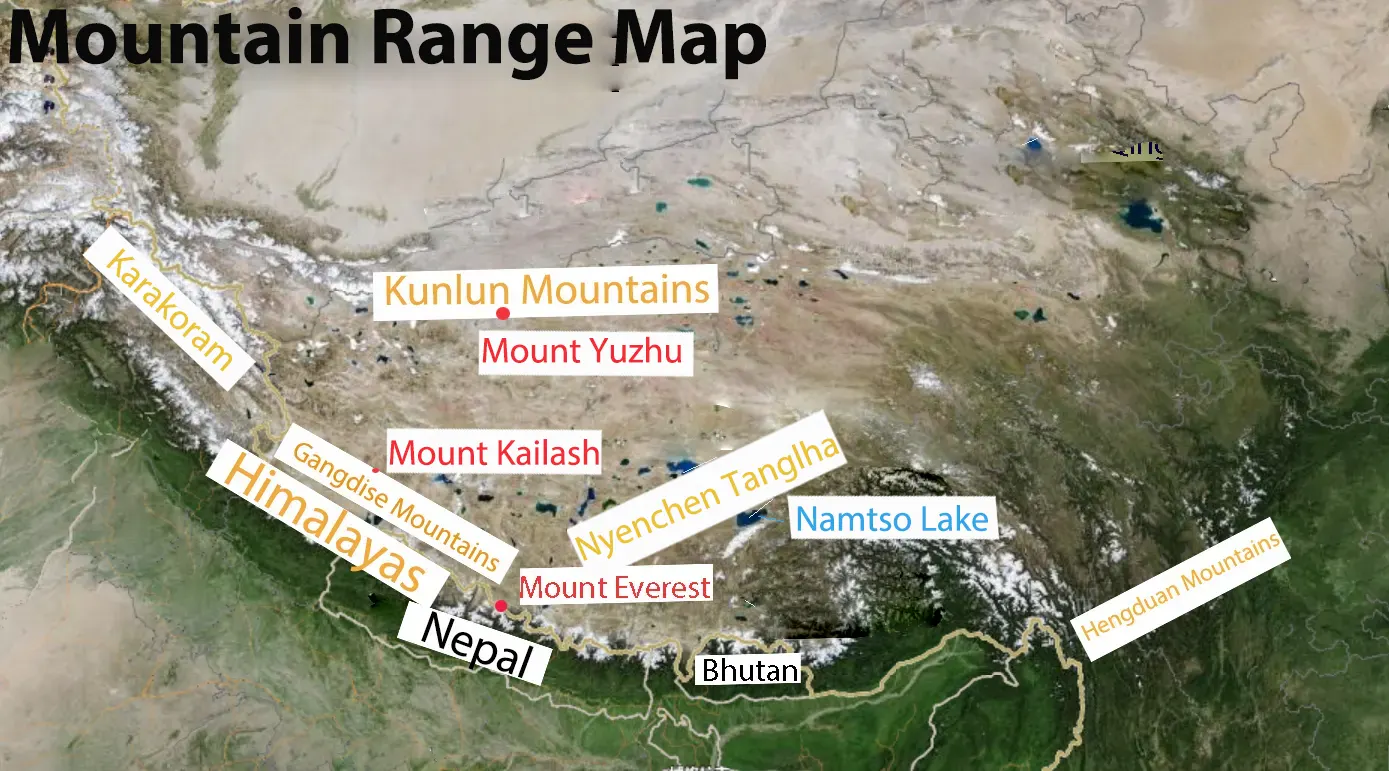
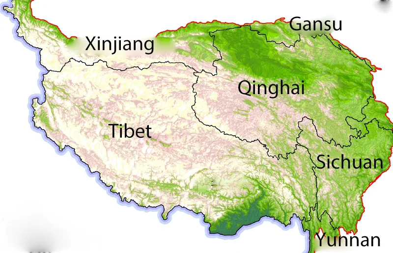 Tibetan Plateau Map
Fact 3: The Tibetan Plateau Is Often Called the Third Pole
The Tibetan Plateau is often called the "Third Pole" because it contains the largest store of ice outside the polar regions. Its glaciers and seasonal snowmelt feed major Asian rivers, providing vital freshwater resources for millions of people. However, its glaciers and snowfields are highly vulnerable to rising temperatures and climate change.
Fact 4: Its Average Elevation Exceeds 4,000 Meters
The Tibetan Plateau has an average elevation of more than 4,000 meters above sea level. At this altitude, atmospheric pressure is much lower, resulting in significantly less oxygen pressure with each breath than at sea level. These conditions affect the region's climate, wildlife, and daily life.
Fact 5: The Tibetan Plateau Was Once Covered by an Ancient Ocean
Hundreds of millions of years ago, parts of the region lay beneath the Tethys Ocean. The Indian and Eurasian tectonic plates later collided, gradually closing the ocean and contributing to the uplift of the Himalayas and Tibetan Plateau. Marine fossils found in local rocks provide evidence of this ancient oceanic past.
Mountains, Rivers & Climate
The Tibetan Plateau is shaped by some of the world's highest mountains, vast glaciers, and major river systems. Its extreme altitude also creates unique weather conditions, making it one of the most distinctive natural environments on Earth.
Fact 6: Mount Everest, the World's Highest Peak, Stands on the Tibetan Plateau's Southern Border
Mount Everest, at 8,848.86 meters, is the world's highest mountain above sea level. It lies on the China-Nepal border, along the southern edge of the Tibetan Plateau. From the Tibetan side, you can reach Everest Base Camp and enjoy views of the mountain's north face.
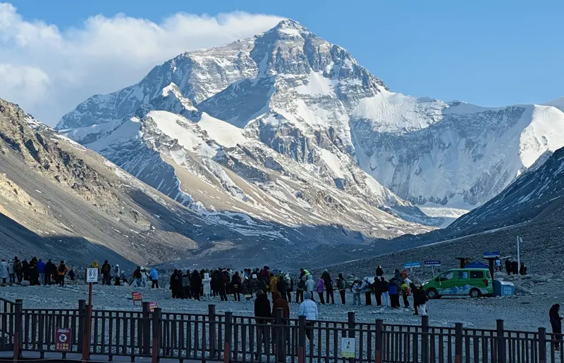 Tibet North Everest Base Camp
Fact 7: The Tibetan Plateau Is Surrounded by Several 8,000-Meter Peaks
The Tibetan Plateau is surrounded by some of the world's highest mountain ranges, including the Himalayas and Karakoram. Besides Mount Everest, Eight of the world's 14 peaks above 8,000 meters are located in these surrounding mountain systems. They include Shishapangma (8,027 m), Cho Oyu (8,188 m), Makalu (8,485 m), Lhotse (8,516 m), Dhaulagiri I (8,167 m), K2 (8,611 m), Manaslu (8,163 m).
Fact 8: Eight Major Mountain Ranges Shape the Tibetan Plateau's Landscape
Eight major mountain ranges define the Tibetan Plateau's landscape: the Himalayas, Kunlun Mountains, Karakoram, Gangdise Mountains, Nyenchen Tanglha Mountains, Tanggula Mountains, Qilian Mountains, and Hengduan Mountains. Together, they create a varied landscape of high peaks, deep valleys, and mountain basins.
Fact 9: The Tibetan Plateau Is the Source of Major Asian Rivers
Often called the "Water Tower of Asia," the Tibetan Plateau is the source region of several major Asian rivers. The Yangtze, Yellow, Mekong, Salween, and Yarlung Tsangpo (Brahmaputra) rivers all originate here. Their waters support agriculture, ecosystems, and millions of people across several countries.
Fact 10: It Contains Vast Glaciers and Thousands of Alpine Lakes
The Tibetan Plateau contains tens of thousands of glaciers and thousands of alpine lakes. These lakes vary in size, depth, and water composition. Famous examples include Lake Namtso, Yamdrok Lake, and Lake Mansarovar, which are known for their high-altitude settings and sacred significance.
Fact 11: Snow Can Fall at High Mountain Passes Even in Summer
Snow can fall at high mountain passes across the Tibetan Plateau, even during summer. Places such as Gawu La and Gyatso La may experience sudden snowfall because of their high elevations and rapidly changing weather. Visitors should bring warm clothing, even during the warmer months.
Fact 12: The Plateau Experiences Large Day-to-Night Temperature Differences
The Tibetan Plateau experiences large temperature differences between day and night. Strong sunshine can make daytime temperatures relatively warm, but temperatures often fall quickly after sunset. This is partly because the thin, dry atmosphere allows heat to escape rapidly at night. The region's rapidly changing weather is sometimes described as "four seasons in one day."
Fact 13: It Receives Strong Ultraviolet Radiation and Has Low Oxygen Levels
The high elevation and thin atmosphere expose the Tibetan Plateau to intense ultraviolet (UV) radiation. Oxygen levels are also much lower than at sea level, which can cause altitude sickness in visitors who are not properly acclimatized. Sunscreen, sunglasses, and gradual acclimatization are essential for a safer trip.
Fact 14: The Tibetan Plateau Plays a Vital Role in Asia's Climate
The Tibetan Plateau plays an important role in shaping atmospheric circulation, monsoon patterns, and weather across Asia. Its high elevation affects the movement of air masses and the distribution of heat and moisture. Glaciers and seasonal snow cover also influence regional water supplies and climate patterns.
History, People & Wildlife
Beyond its dramatic mountains and vast grasslands, the Tibetan Plateau has a rich cultural history and diverse wildlife. Centuries of cultural development and biological adaptation have shaped a vibrant community of people and wildlife thriving in extreme conditions.
Fact 15: The Tibetan Plateau Is Home to Multiple Ethnic Groups, Not Just Tibetans
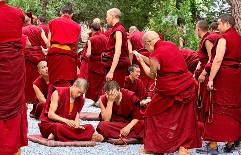
Although Tibetans are the main ethnic group across much of the plateau, they are not the only people living here. Other communities include Han, Hui, Mongolian, Qiang, and Monpa people. Each group has its own traditions, languages, and cultural practices, adding to the region's diversity.
Fact 16: Tibetan Antelopes and Wild Yaks Live in Its High-altitude Grasslands
The Tibetan Plateau is home to a variety of wildlife adapted to its cold climate and high elevation. Tibetan antelopes, also known as chiru, roam the grasslands, particularly in the Hoh Xil region. Wild yaks, Tibetan gazelles, and Tibetan wild asses also inhabit its remote plains. These animals have developed adaptations that help them survive in the plateau's thin air and harsh conditions.
Fact 17: Local Nomadic Communities Have Adapted to the Harsh Plateau Environment
For generations, Tibetan nomadic communities have lived on the plateau's grasslands. Many raise yaks and sheep for milk, meat, wool, and other essential resources. Some traditional herders live in portable yak-hair tents and move seasonally in search of fresh pasture and water. Their way of life reflects a close relationship with the plateau's natural environment.
Transportation & Travel
Once isolated by its remote mountains and high-altitude terrain, the Tibetan Plateau now has a growing transportation network. Modern railways, airports, and highways make it easier for travelers to explore this vast region.
Fact 18: The Qinghai-Tibet Railway Is One of the World's Highest Railway Lines
The Qinghai-Tibet Railway is one of the world's highest railway lines and the first railway connecting Tibet with the rest of China. Stretching approximately 1,956 kilometers from Xining to Lhasa, it passes through vast grasslands, snow-capped mountains, and the Hoh Xil region. Its highest point, Tanggula Pass, reaches 5,072 meters above sea level. The journey offers spectacular views of the Tibetan Plateau's high-altitude landscapes.
Fact 19: The Tibetan Plateau Has Modern Railway Connections, Including the Lhasa-Nyingchi Railway
Railway development is gradually improving transportation across the Tibetan Plateau. Opened in June 2021, the Lhasa-Nyingchi Railway is Tibet's first electrified railway. It stretches approximately 435 kilometers, connecting Lhasa with Nyingchi in southeastern Tibet. Along the way, passengers can enjoy views of deep valleys, rivers, and mountain scenery as the train passes through numerous bridges and tunnels.
Fact 20: The Once-Isolated Tibetan Plateau Is Now Accessible by Air, Rail, and Road
The Tibetan Plateau is now accessible by air, rail, and road. Airports in Lhasa, Nyingchi, Shigatse, and other regional cities provide connections to destinations across China. The Qinghai-Tibet Railway offers an overland route to Lhasa, while highways such as the G318 and G219 connect travelers with remote towns, mountain passes, and scenic attractions. Together, these transport options make it easier to explore different parts of the plateau.
 Tibet Tour
Conclusion
The Tibetan Plateau is a remarkable destination shaped by its unique geography, high-altitude environment, and rich cultural heritage. From exploring ancient monasteries and sacred lakes to discovering remote grasslands and mountain landscapes, there is much to experience across the region. A well-planned Tibet tour offers an excellent way to discover the Roof of the World and experience its natural beauty and local culture.
10 years exp.| 5.0
 | Reviews
Tell me about your travel plan or contact me via inquiry@tibettourism.com
Related Tibet Travel Guide and Advice
Most Popular Tibet Tour Packages
-
![Lhasa Shigatse Mount Everest Small Group Tour]() Small Group Tour
8 Days Lhasa Shigatse Mount Everest Small Group Tour
Promo: Once-in-a-lifetime chance to face the tallest mountain in the world
Dates & Price
![rili]()
![xiala]()
-
![Kathmandu to Lhasa Overland Small Group Tour with EBC]() Small Group Tour
8 Days Kathmandu to Lhasa Overland Small Group Tour with EBC
Promo: Drive Across Himalaya Overland Tour with altitude rising slowly
Dates & Price
![rili]()
![xiala]()
-
![Lhasa Everest Kailash Mansarovar Zhangmu Kathmandu Small Group Tour]() Small Group Tour
12 Days Lhasa Everest Kailash Mansarovar Zhangmu Kathmandu Small Group Tour
Promo: Uncover the spiritual and natural secrets hidden within Tibet
Dates & Price
![rili]()
![xiala]()




Please share your contact information, so we can send you the answer directly by email.

