
 inquiry@tibettourism.com


.webp)


Where Is Nepal Located on the Map?


.webp) Content
ContentNepal is a landlocked South Asian country nestled in the heart of the Himalayas, bounded by China to the north and India to the south, east, and west. As a key gateway to the world's highest mountains, Nepal is a premier destination for trekking and cultural tourism. This comprehensive guide highlights Nepal's exact position on world and Asia maps, along with its borders, neighboring countries, and major geographic features.
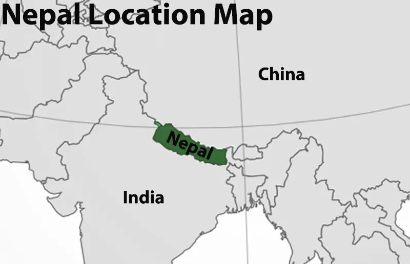 Nepal Location Map
Capital City: Kathmandu, at an elevation of about 1,400 m (4,600 ft).
Administrative Divisions: Nepal has 7 provinces and 77 districts.
Total Area: 147,516 square kilometers.
Geography: Nepal has three main geographic regions: the northern mountain region, the central hill region, and the southern Terai plains.
Highest Point: Mount Everest (8,848.86 m)
Bordering Countries: China to the north and India to the south, east, and west.
Religion: Hinduism is the largest religion, followed by Buddhism, Islam, Kiratism, and Christianity.
Official Language: Nepali. English is also widely used in tourism and business.
Currency: Nepalese Rupee (NPR).
Time Zone: Nepal Standard Time (UTC+5:45).
Emergency Numbers: 100 for police, 101 for fire services, and 102 for ambulance services.
Major Ethnic Groups: Sherpa, Tharu, Tamang, Newar, Limbu, Gurung, Magar, and others.
Staple Foods: Dal Bhat, Momo, Thukpa, and other traditional Nepali dishes.
Wildlife: Bengal tiger, Greater One-horned Rhinoceros, Asian elephant, Himalayan black bear, Himalayan marmot,
gharial, and several species of fox and wild cats.
Natural Resources: Iron, copper, lead, zinc, limestone, and other mineral resources.
Nepal on the World Map
Nepal is located in South Asia, in the Northern and Eastern Hemispheres. It lies at approximately 26°–31°N latitude and 80°–89°E longitude, in the heart of the Himalayan region. On the world map, Nepal is a small landlocked country positioned between China and India, linking the Himalayan mountains with the wider Asian continent.
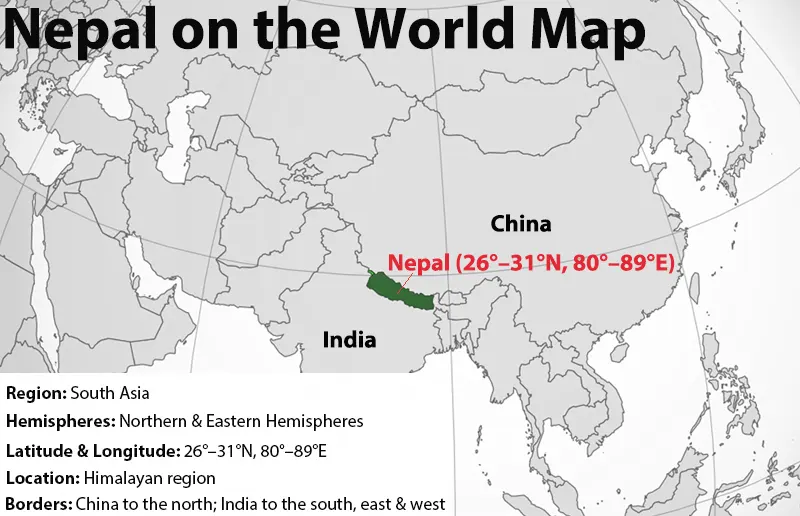 Nepal on the World Map
Nepal on the Asia Map
On the Asia map, Nepal lies in South Asia, along the southern slopes of the Himalayas and near the transition between South Asia and East Asia. China borders Nepal to the north, while India surrounds it to the south, east, and west. Nepal is close to major Himalayan destinations, including Tibet and Mount Everest.
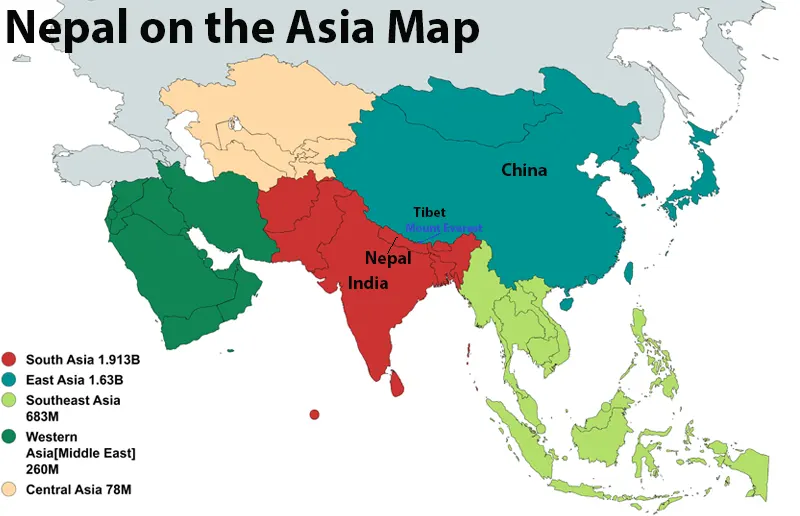 Nepal on the Asia Map
Neighboring Countries and Borders
As a landlocked nation, Nepal is surrounded by India on three sides (south, east, and west) and shares its northern border with China (Tibet). While close to Bangladesh and Bhutan, Nepal is separated from them by narrow strips of Indian territory (the Siliguri Corridor). Nepal does not directly border Bangladesh or Bhutan. However, Bangladesh is about 27 km away across India’s Siliguri Corridor, while Bhutan is around 30 km away.
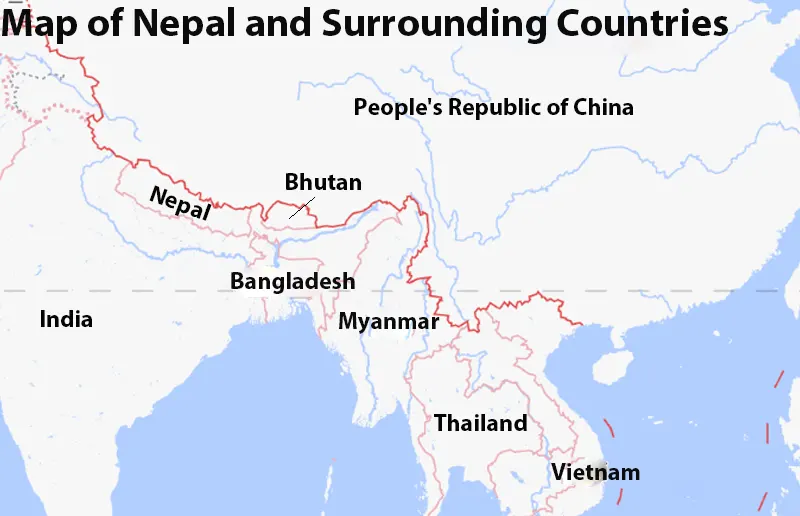 Map of Nepal and Surrounding Countries
Nepal and Tibet, China: Location, Distance & Border
Nepal shares a direct border with Tibet, the southern region of China, along the Himalayas. The Nepal-China border includes major crossings such as Gyirong Border and Zhangmu Border. Kathmandu and Lhasa are about 1,000 km apart by road, depending on the route. This close geographic connection makes Nepal an important gateway for travelers heading to Tibet, China.
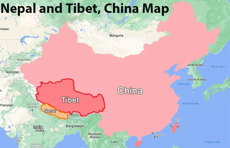 Nepal and Tibet, China Map
Major Cities and Tourist Destinations in Nepal
Nepal’s major cities and tourist destinations include Kathmandu, Pokhara, Bhaktapur, and Lalitpur (also known as Patan). Kathmandu is the capital and a cultural hub, while Pokhara is known for its lakes and Himalayan views. Bhaktapur and Lalitpur are famous for their historic temples, palaces, and traditional architecture. These destinations are popular starting points for trekking, cultural tours, and Nepal-Tibet travel.
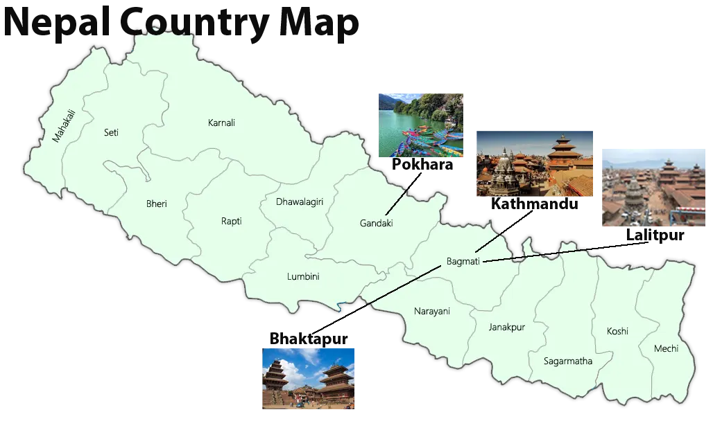 Nepal Country Map
FAQs about Nepal
1) What is Nepal really famous for?
Nepal is best known for the Himalayas and Mount Everest, the world’s highest mountain. It is also famous for
trekking, mountain scenery, Buddhist and Hindu heritage, ancient temples, and rich cultural traditions. Popular
destinations include Kathmandu, Pokhara, Everest Base Camp, and Annapurna.
2) How to get to Nepal?
Most international travelers arrive in Nepal by air through Tribhuvan International Airport (KTM) in Kathmandu,
the country’s main international gateway. Kathmandu’s central location makes it a convenient starting point for
exploring Nepal’s major cities, trekking regions, and Himalayan destinations.
3) How is the weather in Nepal?
Nepal has a diverse climate influenced by altitude and geography. The weather in Nepal ranges from warm and
subtropical in the Terai to cool and alpine in the Himalayas. Spring and autumn generally offer mild
temperatures and clear skies, while summer brings monsoon rain, especially in southern and central Nepal. Winter
is colder, with snow common in high-altitude areas.
4) How close is Nepal to Xizang (Tibet), China?
Nepal is directly south of Tibet in China, with the two regions sharing a border of about 1,400 km (870 miles).
The distance between Kathmandu and Lhasa is approximately 600 km (370 miles) by air.
5) What is the main border crossing between Nepal and Xizang (Tibet), China?
Gyirong Border and Zhangmu Border are the main international land border crossings between Nepal and Tibet in China for travelers.
Gyirong Border connects Gyirong County in Tibet, China with Rasuwagadhi in Nepal and is commonly used for overland trips between Kathmandu and Lhasa.
Zhangmu Border connects Nyalam County in Tibet, China with Tatopani in Nepal. Situated about 115 km from Kathmandu along the historic Arniko Highway, it provides a direct overland route to Lhasa.
6) Can I travel from Nepal to Tibet, China?
Yes, you can travel from Nepal to Tibet in China by air or overland. Foreign travelers must arrange a Tibet Travel Permit and travel with an authorized Tibet travel agency, such as Tibet Horizon. The overland route
usually crosses the Nepal-China border at the Gyirong Border. Currently, land routes are temporarily
unavailable. Please see the Tibet Nepal Travel Update for details.
7) Is Mount Everest in Nepal or Tibet in China?
Mount Everest lies on the border between Nepal and Tibet, China. Its southern side is in Nepal, while its
northern side is in Tibet, China. You can visit Everest Base Camp in Nepal or join an EBC tour in Tibet for different views of the world’s highest mountain.
Conclusion
Positioned in the center of the majestic Himalayas, Nepal offers a unique geographic and cultural bridge in South Asia. Its unique location makes it a gateway to Mount Everest, Tibet, and the wider Himalayan region. Understanding Nepal's location on world and the Asia map can help you better plan your Nepal Tibet tour.
10 years exp.| 5.0
 | Reviews
Tell me about your travel plan or contact me via inquiry@tibettourism.com
Related Tibet Travel Guide and Advice


Most Popular Tibet Tour Packages
-
![Lhasa Everest Base Camp Kathmandu Overland Small Group Tour]() Small Group Tour
Small Group Tour7 Days Lhasa Everest Base Camp Kathmandu Overland Small Group Tour
Promo: Classic overland travel route from Lhasa to Kathmandu via Gyirong / Nyalam
Dates & Price
![rili]()
![xiala]()
-
![Lhasa Shigatse Mount Everest Small Group Tour]() Small Group Tour
Small Group Tour8 Days Lhasa Shigatse Mount Everest Small Group Tour
Promo: Once-in-a-lifetime chance to face the tallest mountain in the world
Dates & Price
![rili]()
![xiala]()
-
![Kathmandu to Lhasa Overland Small Group Tour with EBC]() Small Group Tour
Small Group Tour8 Days Kathmandu to Lhasa Overland Small Group Tour with EBC
Promo: Drive Across Himalaya Overland Tour with altitude rising slowly
Dates & Price
![rili]()
![xiala]()


.webp)


Please share your contact information, so we can send you the answer directly by email.

